Mae Ya Waterfall
Overview
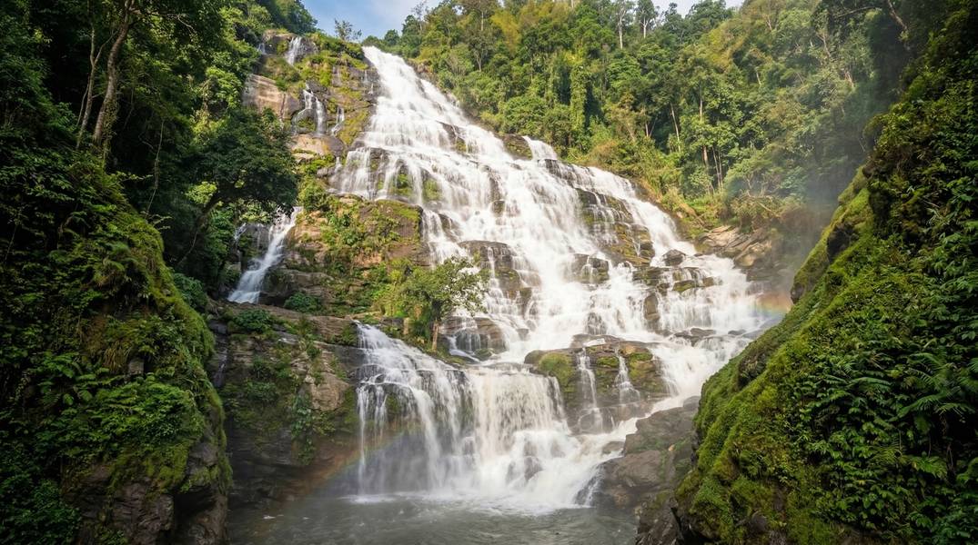
น้ำตกแม่ยะ • Mae Ya Waterfall (Nam Tok Mae Ya)
Known as the “Queen of Waterfalls” (ราชินีแห่งน้ำตก), Mae Ya is the largest and most celebrated waterfall in Doi Inthanon National Park — a 260-meter cascade tumbling over 30 tiers of granite cliff on the southern slopes of Thailand’s highest mountain massif. During the rainy season, the falls expand to approximately 100 meters wide, creating a massive white curtain draped over the granite face that has made Mae Ya one of the most photographed natural landmarks in northern Thailand.
Mae Ya is ranked as Thailand’s second most beautiful waterfall after Thi Lo Su Waterfall in Tak Province. Unlike Thi Lo Su’s multi-day jungle expedition, Mae Ya is remarkably accessible — a gentle 600-meter forest walk from a car park, making it one of the few world-class waterfalls that medical tourists can realistically visit during recovery.
Doi Inthanon National Park, Thailand’s 6th national park established in 1972, covers 482 sq km of the Thanon Thong Chai mountain range in Chiang Mai Province. The park protects habitat ranging from lowland deciduous forest to the country’s only sphagnum bog above 1,800 meters.
Important: Park fees, opening hours, and trail conditions are subject to change without notice. Verify current information with Doi Inthanon National Park staff or local operators before visiting. Weather conditions and water flow vary significantly by season and cannot be guaranteed.
Why Mae Ya is Special
Northern Thailand’s Crown Jewel
Mae Ya’s 260-meter total height across 30+ tiers of stepped granite makes it the largest waterfall in Doi Inthanon National Park and one of the most impressive in all of Thailand. The main accessible tier — approximately 40-50 meters tall — is the highlight, where water cascades down a sheer granite wall in a curtain-like flow.
Note: The exact height of Mae Ya has never been formally surveyed. Sources cite heights ranging from 250 to 280 meters for the total cascade including all tiers. The 260-meter figure from Thai-language official sources is used as the primary reference.
Accessible Grandeur
What sets Mae Ya apart from many of Thailand’s great waterfalls is accessibility. While Thi Lo Su requires a multi-day jungle expedition and Thi Lo Jo demands river rafting, Mae Ya delivers comparable visual impact via a 20-30 minute walk on a mostly paved trail — one of the few premier waterfalls in Southeast Asia accessible to visitors with moderate fitness levels.
Part of Doi Inthanon National Park
Mae Ya sits within one of Thailand’s most ecologically significant national parks:
- 482 sq km of protected montane forest
- 382-510 bird species — the highest bird diversity of any single site in Thailand
- 65+ mammal species, including gibbons, wild boar, deer, and serow
- Endemic species found nowhere else on earth, including Deignan’s Babbler and the Chiang Mai dwarf gecko
- Elevation range from 800 m to 2,565 m (Thailand’s highest point)
Natural Features & Ecology
Landscape
The waterfall occupies a steep granite valley on the southern slopes of the Doi Inthanon massif, surrounded by moist evergreen forest transitioning from lowland deciduous to highland evergreen zones. The surrounding landscape is part of the Thanon Thong Chai mountain range, with the waterfall base sitting at an estimated 750-900 meters above sea level.
Multiple streams — Khun Lam Huai Mae Ya, Huai Luang, Huai Hom, and Huai Pang Tong — feed the cascade, which flows downstream into the Mae Klang River and eventually the Ping River at Chom Thong District.
Flora
Doi Inthanon National Park protects diverse forest types across its elevation range:
| Forest Type | Elevation | Notable Features |
|---|---|---|
| Mixed deciduous / teak | Lower elevations | Teak forests, dipterocarp species |
| Dry evergreen | Mid elevations | Dense canopy, year-round foliage |
| Moist evergreen / cloud forest | Above 1,800 m | Epiphytes, ferns, mosses |
| Pine forest | Mid-high elevations | Open understorey |
| Sphagnum bog | Above 1,800 m | Thailand’s only sphagnum habitat |
Notable flowering: Siamese sakura (Prunus cerasoides) blooms in late January to early February near Siriphum Waterfall — a popular seasonal attraction within the park.
Fauna
The park hosts remarkable biodiversity. Wildlife sightings depend on season, time of day, location, and chance — animals roam freely across 482 sq km.
Mammals (~65 species, approximately half are bats):
- Wild boar, gibbons (commonly heard), deer, serow
- Various smaller mammals throughout the forest zones
Reptiles & Amphibians (~50 reptile, ~30 amphibian species):
| Species | Status | Notes |
|---|---|---|
| Chiang Mai Dwarf Gecko | Endemic | Found only on Doi Inthanon |
| Doi Inthanon Bent-toed Gecko | Endemic | Restricted range |
| Chiang Mai Newt | Endemic | Mountain streams |
| Inthanon Horned Toad | Endemic | High elevation |
| Inthanon Stream Toad | Endemic | Near waterfalls |
| Doi Inthanon Torrent Frog | Endemic | Waterfall spray zones |
Venomous snakes: Pope’s Pit Viper, Guo’s Green Pit Viper, and Himalayan Mountain Pit Viper are recorded in the park. Stay on trails and wear closed-toe shoes.
Birdwatching
Doi Inthanon records 382-510 bird species — the highest avian diversity of any site in Thailand — making it one of Asia’s premier birdwatching destinations.
Near Mae Ya Waterfall:
- Plumbeous Redstart — commonly seen on rocks near flowing water
- Slaty-backed Forktail — along streams near waterfalls
- Blue Whistling-Thrush — shaded waterfall areas
Elsewhere in the park (higher elevations):
- Ashy-throated Leaf Warbler — found nowhere else in Thailand
- Deignan’s Babbler (Stachyris rodolphei) — endemic, only known from Doi Inthanon
- Green-tailed Sunbird (endemic race Aethopyga nipalensis angkanensis)
- Himalayan Shortwing, Pygmy Cupwing, Green Cochoa
- Long-tailed Broadbill, Rusty-naped Pitta, Silver-eared Mesia
Best birding period: February to April (breeding season plus winter visitors at higher elevations). Early morning (06:30-09:00) is optimal.
Geological Features
- 30+ tiers of stepped granite cliff forming the waterfall cascade
- Part of the Thanon Thong Chai mountain range
- Granite rock formations characteristic of the southern Doi Inthanon massif
Water Features in Doi Inthanon National Park
| Waterfall | Height | Access | Notes |
|---|---|---|---|
| Mae Ya Waterfall | ~260 m (30+ tiers) | Separate entrance, 600 m walk | Largest in the park |
| Wachirathan Waterfall | ~40 m | Main park road | Spectacular spray, easily accessible |
| Sirithan Waterfall | Moderate | Main park road viewpoint | Viewable from road |
| Mae Klang Waterfall | ~100 m (multi-tier) | Near park entrance | Multiple tiers to explore |
| Siriphum Waterfall | Moderate | Near summit road | Famous for sakura views in February |
| Pha Dok Siew Waterfall | Moderate | 2.6 km trail (guide required) | Remote, scenic |
Activities & Experiences
Mae Ya Waterfall Trail (Car Park to Falls)
The main attraction — and the reason Mae Ya is accessible to medical tourists.
| Detail | Information |
|---|---|
| Distance | ~600 meters one way (1.2 km round trip) |
| Difficulty | Easy to moderate |
| Elevation Change | Undulating, some stairs |
| Surface | Mostly concreted, some sandy/rocky sections near the falls |
| Shade | Good — trail runs through forested area |
| Time | 20-30 minutes each way |
| Post-Surgery Suitability | Suitable from recovery week 2-3 for minor procedures. Sturdy shoes required. Children aged 5-6 can manage the trail |
Extended Walk to Upper Tiers
| Detail | Information |
|---|---|
| Distance | ~500 meters additional from lower viewpoint |
| Difficulty | Moderate |
| Surface | Rocky, steeper sections |
| Time | Additional 30-45 minutes |
| Notes | Upper viewpoint offers the signature curtain-of-water view. Not recommended during early post-surgery recovery |
Photography
Mae Ya is one of northern Thailand’s most photogenic waterfalls.
Best Spots:
- Lower viewpoint — full frontal view of the cascade
- Upper tier viewpoint — close-up curtain-of-water perspective
- The distinctive tree growing midway up the falls — the signature compositional element
Timing:
- Best: Early morning (arrive ~07:30) for directional sunlight on the falls and fewest visitors
- Avoid: Late afternoon (~16:00+) when the sun drops below the canyon, leaving the falls in shadow
- Overcast days: Actually favorable — clouds diffuse harsh light on the white water, making photography easier
Tips:
- Use the tree midway up the falls as a compositional anchor
- Include a person for scale to convey the waterfall’s enormous size
- November offers the best combination of water flow, clear skies, and dry trails
- Bring a lens cloth — spray reaches the viewpoints during high flow
Wildlife Watching
| Detail | Information |
|---|---|
| Best Species Near Mae Ya | Plumbeous Redstart, Slaty-backed Forktail, Blue Whistling-Thrush, butterflies, dragonflies near spray zone |
| Best Times | Early morning (06:30-09:00) |
| Best Birding Months | February-April (breeding + winter visitors) |
| Reality | Mae Ya is not a primary birdwatching site — the park’s higher-elevation trails offer better birding. Waterfall species can be spotted with patience |
Wildlife sightings cannot be guaranteed. Animals are wild and free-roaming across the park.
Swimming & Wading
Swimming is not officially permitted at Mae Ya Waterfall. Wading in shallow areas is tolerated at low water levels during dry season, but exercise extreme caution. Strong currents are present during and after rain. Never enter water alone. Flash flood risk exists during heavy rains.
Camping
| Detail | Information |
|---|---|
| Available | Yes — main campground near park headquarters (separate area from Mae Ya). Tent sites reportedly available near Mae Ya — contact park staff |
| Booking | DNP online booking at portal.dnp.go.th or walk-in |
| Bungalow Prices | 1,000-6,500 THB/night (20% weekday discount) at park headquarters area |
| Camping Prices | 225 THB/day for 3-person tent; 60 THB/person for sleeping gear |
Combine with Other Doi Inthanon Attractions
Mae Ya can be combined with visits to other park highlights (accessed via the separate main summit road entrance):
- Doi Inthanon Summit (2,565 m) — Thailand’s highest point
- Royal Twin Pagodas — Phra Mahathat Naphamethinidon & Naphaphonphumisiri (additional 100 THB/person)
- Kew Mae Pan Nature Trail — 2.5 km, moderate difficulty, guide required (220 THB/group). Closed June-October for forest recovery
- Ang Ka Luang Nature Trail — boardwalk through mossy cloud forest near the summit
- Pha Dok Siew Trail — 2.6 km, guide required
- Hmong Market at the summit — local crafts and produce
- Wachirathan Waterfall — spectacular spray, easily accessible from the main road
Trail Guide
Trail 1: Mae Ya Waterfall Trail (Main Trail)
| Detail | Specification |
|---|---|
| Distance | 600 m one way |
| Elevation Gain | Minimal, undulating |
| Difficulty | Easy to moderate |
| Surface | Concrete path, some sandy/rocky sections near the falls |
| Shade Coverage | Good — forested canopy throughout |
| Rest Points | Rest spots available along trail |
| Facilities | Food and drink stalls at parking area |
| Estimated Time | 20-30 minutes one way |
Trail Notes: The path is well-maintained and mostly paved. Some sections near the waterfall become rocky and uneven. Trails can be slippery when wet — sturdy shoes with good grip are essential. Handrails are present on some stair sections.
Trail 2: Upper Tiers Extension
| Detail | Specification |
|---|---|
| Distance | ~500 m additional from lower viewpoint |
| Elevation Gain | Moderate — steep zigzag sections |
| Difficulty | Moderate |
| Surface | Rocky, unpaved |
| Shade Coverage | Moderate |
| Estimated Time | 30-45 minutes round trip from lower viewpoint |
Trail Notes: Steeper terrain with zigzag sections near upper tiers. This is where the signature curtain-of-water view is found. Not suitable for early post-surgery recovery or visitors with balance concerns. Rocky and slippery when wet.
For Medical Tourists
Accessibility Assessment
Mae Ya Waterfall is one of the more accessible major waterfalls in Thailand, making it a realistic nature destination for medical tourists recovering in Chiang Mai.
Favorable factors:
- Short, mostly paved trail (600 m to lower viewpoint)
- Good shade coverage reduces heat exposure
- Cooler mountain temperatures than Chiang Mai city (roughly 15-28°C)
- Food and drink available at the parking area
- Ranger Station No. 3 (Mae Ya) provides on-site park staff presence
Challenging factors:
- 1.5-2 hour drive each way from Chiang Mai
- Some stairs and uneven terrain on the trail
- No wheelchair access
- Limited mobile phone signal
- Nearest hospital is 30-45 minutes away by car
Post-Surgery Suitability
| Procedure Type | Suitability | Notes |
|---|---|---|
| Dental (simple) | ✅ Suitable from week 2-3 | The 600 m paved walk is manageable. Wear sturdy shoes. Stick to lower viewpoint |
| Minor cosmetic | ✅ Suitable from week 2-3 | Cooler temperatures beneficial. Avoid upper tiers. Protect surgical sites from spray |
| LASIK / vision | ⚠️ Suitable from week 3-4 with doctor approval | Waterfall spray and dust possible. Bring protective eyewear |
| Orthopedic | ⚠️ Suitable from week 3-4 with doctor approval | Lower viewpoint only. Avoid if balance issues. Uneven terrain near falls |
| Cardiac | ⚠️ Moderate caution, week 3-4+ with doctor approval | Elevation (~750-900 m) is not a concern. Moderate walking. Cooler temperatures beneficial |
| Major surgery | ❌ Not recommended in early recovery | The 1.5-2 hour drive plus walking may be too taxing. Consider recovery week 4+ with medical clearance |
Nearest Medical Facilities
| Facility | Distance from Mae Ya | Travel Time | Type |
|---|---|---|---|
| Chom Thong Hospital (โรงพยาบาลจอมทอง) | ~25-30 km | 30-45 minutes by car | 207-210 bed secondary-level public hospital |
| Bangkok Hospital Chiang Mai | ~80 km | 1.5-2 hours | Private, international standard, 24-hour emergency |
| Chiang Mai Ram Hospital | ~80 km | 1.5-2 hours | Private hospital |
| Maharaj Nakorn Chiang Mai Hospital | ~80 km | 1.5-2 hours | Public university hospital (largest in northern Thailand) |
Chom Thong Hospital (259 Moo 2, Tambon Doi Kaeo, Amphoe Chom Thong, Chiang Mai 50160, Route 108 km 60) is the nearest full hospital. It is a secondary-level public hospital — adequate for non-critical emergencies but not equipped for complex trauma or cardiac events.
Emergency Contacts
- 1669 — Medical emergency / ambulance (English available; rural response time may be extended)
- 1155 — Tourist Police (24 hours, English-speaking)
- 191 — Police emergency
- Doi Inthanon National Park HQ: (+66) 5328 6728-9
Recovery Activity Recommendations
For medical tourists who can manage the trail, Mae Ya offers:
- Light nature walks — the 600 m paved trail to the lower viewpoint provides gentle exercise in a beautiful setting
- Photography — minimal physical exertion at the viewpoint; bring a camera and enjoy the scenery
- Fresh mountain air — cooler temperatures and clean air at elevation, away from urban pollution
- Combine with temple visit — Wat Phra That Si Chom Thong Worawihan (flat, accessible, free entry by donation) is a 15th-century Lanna temple on the return route to Chiang Mai
Medical Advisory: Consult your doctor before any outdoor activities post-procedure. Carry all prescribed medications, sufficient water, and sun protection. Arrange private transport with a driver so you can rest during the journey. Inform someone of your plans before visiting, as mobile signal is limited.
Getting There
From Chiang Mai (Primary Route)
| Stage | Description | Duration |
|---|---|---|
| Chiang Mai to Chom Thong | Highway 108 southwest, well-paved | ~1-1.5 hours |
| Chom Thong to Mae Ya Checkpoint | Turn onto Route 1009, follow signs to Mae Ya Waterfall via village road (14 km) | ~20-30 minutes |
| Checkpoint to Falls | Walk on forest trail | ~20-30 minutes |
Total: Approximately 1.5-2 hours driving + 20-30 minutes walking each way.
Transport Options
| Option | Details | Best For |
|---|---|---|
| Private car / driver | Hire from Chiang Mai. Best flexibility. Driver can wait | Medical tourists, families |
| Self-drive rental | Highway 108 well-paved. Village road to Mae Ya has curves but is navigable | Independent travelers |
| Grab car | Book from Chiang Mai, ask driver to wait | Mae Ya-only visit |
| Organized tour | Join Doi Inthanon day tour from Chiang Mai | Budget travelers, combining attractions |
| Bus + songthaew | Bus from Chiang Mai to Chom Thong (Highway 108), then songthaew toward park area | Budget option, less convenient |
From Bangkok
Fly to Chiang Mai International Airport (CNX) — approximately 1.5 hours. Multiple daily flights on Thai Airways, Bangkok Airways, Thai AirAsia, Nok Air, and Thai Lion Air. Then drive 1.5-2 hours southwest to Mae Ya.
Critical Navigation Note
Mae Ya has its own separate entrance checkpoint — it is NOT accessed via the main Doi Inthanon gate leading to the summit. Many first-time visitors make this mistake. Search GPS specifically for “Mae Ya Waterfall” (น้ำตกแม่ยะ). The turnoff from Highway 108 leads 14 km down village roads to the Mae Ya checkpoint. The same national park ticket covers both entrances.
Road Conditions
- Highway 108: Well-paved, standard highway
- Village road to Mae Ya (14 km): Paved with curves, navigable in a standard car. Can be slippery after rain
- Parking: Available at Mae Ya waterfall car park (free with park entry)
Park Fees
| Category | Fee |
|---|---|
| Foreign adult | 300 THB |
| Foreign child (ages 3-14) | 150 THB |
| Thai adult | 50-60 THB |
| Thai child | 20-30 THB |
| Car | 30 THB |
| Motorcycle | 20 THB |
Ticket Validity: The same ticket covers Mae Ya Waterfall and the main Doi Inthanon park area for up to 5 consecutive days.
Payment: Cash is the primary method. QR payment may be available at the main checkpoint.
Additional Fees: The Royal Twin Pagodas near the summit charge a separate 100 THB per person (under different management from the park).
Pricing Disclaimer: Park fees are set by the Department of National Parks (DNP) and are subject to change without notice. Some sources suggest a possible increase to 400 THB for foreign adults. Verify current rates at the checkpoint or via the DNP website (portal.dnp.go.th).
Accommodation
In the Park
| Type | Details | Price Range |
|---|---|---|
| Bungalows | Near park headquarters (not at Mae Ya) | 1,000-6,500 THB/night (20% weekday discount) |
| Camping | Park campground near headquarters | 225 THB/day for 3-person tent; 60 THB/person for sleeping gear |
Booking: Online at portal.dnp.go.th or walk-in at park headquarters. Book in advance for November-February peak season.
Nearby Options
| Accommodation | Details |
|---|---|
| Little Home Inthanon Resort | 400-1,000 THB/night, near park checkpoint |
| Doiintanon View Resort | Near southeast entrance |
| Suan Sook Homestay | Ban Mae Klang area |
| Chom Thong town | Budget hotels and guesthouses |
| Mae Chaem area | Mae Chaem Hotel (wooden bungalows, 400-600 THB/night) |
Booking Tip: Stay in Chom Thong or near the park entrance for early morning access to Mae Ya. This allows arrival by 07:30 for the best photography light and fewest crowds.
Accommodation prices are approximate and subject to change. Verify rates directly with properties before booking.
Practical Tips
What to Pack
Essential Items:
- Sturdy closed-toe shoes with good grip (trails slippery when wet)
- Insect/mosquito repellent
- Sunscreen and hat
- Rain jacket or poncho (particularly June-November)
- 1-2 liters of water
- Camera and lens cloth (spray reaches viewpoints)
- Cash in THB (limited card facilities)
- Offline maps downloaded to phone
Recommended:
- Long pants and socks (leech protection in wet season)
- Light layers (cooler than Chiang Mai city at elevation)
- Swimwear and water shoes (if wading in shallow areas during dry season)
- Binoculars for birdwatching
- Small first aid kit
What NOT to Bring
- Alcohol — prohibited in all Thai national parks
- Food and drink near the waterfall — signs posted restricting consumption near the falls
- Single-use plastics — discouraged within national parks
- Drones — check current park regulations before flying
Leech & Insect Guidance
- Leeches: Possible during wet season (June-October) and near streams. Wear long pants tucked into thick socks, closed-toe shoes. Carry salt for removal. Leech bites are not dangerous but contain an anticoagulant that causes extended bleeding — clean wounds promptly with antiseptic
- Mosquitoes: Bring repellent, particularly for dusk visits. Insect activity is higher during rainy season
Snake Safety
Venomous snake species (Pope’s Pit Viper, Guo’s Green Pit Viper, Himalayan Mountain Pit Viper) are recorded in the park. Encounters are uncommon on the main trail. Stay on marked paths, wear closed-toe shoes, and watch your step on rocky sections.
Weather by Season
The Mae Ya area sits at an estimated 750-900 m elevation in a tropical monsoon / highland transition zone. Temperatures are cooler than Chiang Mai city.
| Season | Temperature Range | Conditions |
|---|---|---|
| Cool season (Nov-Feb) | 15-25°C | Clear skies, comfortable. Summit can reach 0°C at night |
| Hot season (Mar-May) | 20-30°C | Warming, haze from burning season, reduced water flow |
| Rainy season (Jun-Oct) | 18-28°C | Regular afternoon showers, lush green, maximum water flow |
Water Safety
- Swimming not officially permitted
- Wading in shallow areas tolerated at low water levels only
- Strong currents during rainy season — exercise extreme caution
- Flash flood risk during heavy rains — move to high ground if water rises
- Never enter the water alone
Environmental Responsibility
National Park Rules
Doi Inthanon National Park is managed by Thailand’s Department of National Parks (DNP). All visitors must observe park rules:
- Do not feed wildlife
- Stay on marked trails at all times
- Do not collect plants, rocks, or natural materials
- No loud music or disturbance to wildlife
- All waste must be packed out — Leave No Trace
- No hunting, trapping, or fishing
Prohibited Items
- Alcohol (prohibited in all Thai national parks)
- Food and drink near the waterfall (signs posted)
- Single-use plastics (discouraged)
- Drones (check current regulations)
Ethical Wildlife Guidelines
Wildlife at Mae Ya and Doi Inthanon is wild and free-roaming. Sightings are never guaranteed.
- Maintain safe distance from all animals
- Use binoculars for closer observation rather than approaching
- Do not attempt to attract wildlife with food or calls
- Report injured wildlife to park rangers
Conservation Programs
The park supports several conservation efforts:
- Doi Inthanon National Park reforestation programs
- Kew Mae Pan Nature Trail annual closure (June-October) for forest recovery
- Hill tribe community conservation partnerships
- Protection of endemic species found nowhere else on earth
Community Tourism
Hmong communities within park boundaries maintain a vibrant presence, including the Hmong Market at the summit offering local crafts and produce. Some guided trails are led by local Hmong guides, providing community-based tourism income.
Seasonal Guide
Month-by-Month Conditions
| Month | Conditions | Water Flow | Rating |
|---|---|---|---|
| January | Cool, dry. Clear skies. Siamese sakura blooming near Siriphum. Peak tourist season. Summit near freezing at night | Low-Moderate | Good |
| February | Cool, dry. Best birdwatching begins. Good visibility | Moderate | Good |
| March | Warming. Burning season begins — haze possible. Fewer tourists | Reduced | Moderate |
| April | Hot season peak. Significant haze. Lowest water levels | Lowest | Least Recommended |
| May | Hot, transitioning. Early rains begin. Kew Mae Pan Trail closes | Rising | Transitional |
| June | Rainy season starts. Regular afternoon showers. Lush green. Leeches appear | Growing | Moderate |
| July | Heavy rains. Full waterfalls. Trail caution required | High | Good (with caution) |
| August | Heavy rains continue. Impressive water flow. Fewer tourists | Very High | Good (with caution) |
| September | Rains easing. Spectacular water flow. Excellent photography | Near Maximum | Excellent |
| October | Rains diminishing. Waterfalls still powerful. Landscapes at peak green | Very High | Excellent |
| November | Dry season begins. Strong flow + clear skies + dry trails. Ideal overall | High | Best Month |
| December | Cool, dry. Peak season begins. Summit very cold. Heavy tourist traffic | Moderate | Good |
Best Months for Activities
| Activity | Best Months | Notes |
|---|---|---|
| Waterfall viewing | Sep-Nov | Maximum water flow with improving conditions |
| Photography | Nov (best), Sep-Oct | Strong flow + clear skies. Morning arrival for best light |
| Hiking | Nov-Feb | Dry trails, comfortable temperatures |
| Birdwatching | Feb-Apr | Breeding + winter visitors at higher elevations |
| Medical tourist visit | Nov-Feb | Best trail conditions, cool temperatures, dry weather |
Migration & Flowering Calendar
- Winter migrants (November-March): Himalayan species arrive at higher elevations
- Breeding season: February-April
- Siamese sakura (Prunus cerasoides): Late January to early February near Siriphum Waterfall — a popular seasonal event
Nearby Attractions
Nature Sites
| Attraction | Description |
|---|---|
| Wachirathan Waterfall | ~40 m, spectacular spray, along main park road. Easily accessible |
| Sirithan Waterfall | Viewpoint accessible from the main road |
| Mae Klang Waterfall | 100 m multi-tier, near park entrance |
| Siriphum Waterfall | Sakura views in February |
| Pha Dok Siew Waterfall | 2.6 km trail, guide required |
| Doi Inthanon Summit | 2,565 m — Thailand’s highest point |
| Ang Ka Luang Nature Trail | Mossy cloud forest boardwalk near summit |
| Kew Mae Pan Nature Trail | 2.5 km, stunning views, open November-May only |
| Royal Twin Pagodas | Naphamethinidon & Naphaphonphumisiri, near summit |
| Pha Chor | Erosion canyon (separate location nearby) |
Cultural Sites
| Site | Description |
|---|---|
| Wat Phra That Si Chom Thong Worawihan | 15th-century Lanna temple with sacred Buddha relic. Vipassana meditation center. Free entry (by donation). 1.5 km south of Doi Inthanon park turnoff on Route 108. Flat and accessible — good combination with Mae Ya for medical tourists |
| Hmong Market at Summit | Local crafts, produce, and food at the Doi Inthanon summit |
| Ban Mae Klang Luang | Karen hill tribe village within the park |
| Royal Agricultural Station Inthanon | Flower gardens and research station |
Markets & Dining
- Food stalls at Mae Ya parking area
- Multiple restaurants near park headquarters
- Hmong Market food stalls at the summit
- Chom Thong town restaurants
Related Nature Destinations
Similar Waterfalls
- Thi Lo Su Waterfall (Tak Province) — Thailand’s largest waterfall. Multi-day adventure, high physical demand. Not suitable for medical tourist recovery
- Erawan National Park (Kanchanaburi) — 7-tier limestone waterfall with emerald pools. More accessible, moderate physical demand
- Wachirathan Waterfall — within Doi Inthanon, easily accessible from the main park road
Suggested Nature Itineraries by Recovery Stage
| Recovery Stage | Suggested Destinations |
|---|---|
| Week 2-3 (minor procedures) | Mae Ya lower viewpoint, Wachirathan Waterfall (roadside), Ang Ka Luang boardwalk |
| Week 3-4 (moderate procedures) | Mae Ya full trail, Royal Twin Pagodas, Kew Mae Pan Nature Trail |
| Week 4+ (major procedures) | Doi Inthanon summit drive, Mae Klang Waterfall, combine with Chiang Mai temple visits |
Safety Summary
- Trail conditions: Trails can be slippery when wet. Wear sturdy shoes with good grip
- Stairs and uneven terrain: Present on the main trail and more pronounced on upper tier paths
- Strong currents: Present at the waterfall during rainy season. Swimming not officially permitted
- Flash floods: Risk during heavy rains. Move to high ground if water rises suddenly
- Cooler temperatures: Prepare for temperatures lower than expected — bring layers
- Leeches: Possible in wet season. Wear protective clothing
- Snakes: Venomous species recorded in the park. Stay on trails, wear closed shoes
- Limited mobile signal: Download offline maps. Inform someone of your plans
- Ranger presence: Ranger Station No. 3 (Mae Ya) is located in the area. Park staff present at checkpoint and parking
Disclaimer: Outdoor activities in natural areas involve inherent risks including slippery trails, wildlife encounters, unpredictable weather, and limited access to medical care. Trail conditions, water flow, and weather are unpredictable and subject to change without notice. Park fees and opening hours may change without notice. Wildlife sightings cannot be guaranteed. Consult your physician before any outdoor activities post-surgery. Physical difficulty ratings are estimates — individual fitness, weather conditions, and trail conditions may alter the actual experience. Carry comprehensive travel insurance.
Frequently Asked Questions
Is Mae Ya Waterfall suitable for medical tourists recovering from procedures?
Mae Ya is one of the more accessible major waterfalls in Thailand. The 600-meter paved trail to the lower viewpoint is manageable for patients recovering from minor procedures (dental, minor cosmetic) from recovery week 2-3 onward. The cooler mountain temperatures are more comfortable than Bangkok heat. However, the 1.5-2 hour drive each way from Chiang Mai is the main consideration — arrange a private car with rest stops. Stick to the lower viewpoint and avoid the upper tiers. Always consult your doctor before outdoor activities post-procedure.
How do I get to Mae Ya Waterfall?
From Chiang Mai, drive southwest via Highway 108 toward Chom Thong (approximately 55-70 km, about 1.5-2 hours). At Chom Thong, take the turnoff to Route 1009 and follow signs for Mae Ya Waterfall — NOT the main Doi Inthanon gate. The last 14 km follows a village road with curves but is paved and navigable. IMPORTANT: Mae Ya has its own separate entrance checkpoint, distinct from the main Doi Inthanon summit road entrance.
What is the best time to visit?
September to November offers the ideal combination — the rainy season has produced maximum water flow, skies are clearing, and trails are drying out. November is the photographer's sweet spot with strong flow, clear skies, and dry trails. March to May (hot season) brings the lowest water flow, haze from burning season, and the least impressive viewing. December to February is cool and clear but water flow is moderate.
Can I swim at Mae Ya Waterfall?
Swimming is not officially permitted at Mae Ya Waterfall. Wading in shallow areas is tolerated at low water levels, but exercise extreme caution. Strong currents are present during rainy season, and flash flooding is a risk during heavy rains. Never enter the water alone. Water shoes are recommended if wading.
Is there mobile phone signal at the waterfall?
Mobile signal is limited and unreliable at Mae Ya Waterfall. The location is 14 km off the main road in a forested valley. Download offline maps before visiting and ensure someone knows your plans. The ranger station at Mae Ya may have slightly better connectivity.
Do I need to pay separately for Mae Ya and Doi Inthanon?
No. The same Doi Inthanon National Park ticket (300 THB for foreign adults) covers both Mae Ya Waterfall and all other attractions within the park, valid for up to 5 consecutive days. However, Mae Ya has its own separate entrance checkpoint — you cannot access it via the main Doi Inthanon summit road gate. The Royal Twin Pagodas near the summit have a separate 100 THB per person fee under different management.
How physically demanding is the trail?
The main trail from the car park to the lower waterfall viewpoint is 600 meters one way, mostly concreted, with good shade through forested areas. It takes 20-30 minutes each way and is rated easy to moderate. Children aged 5-6 can manage it. The trail to the upper tiers adds approximately 500 meters of rockier, steeper terrain rated moderate. Sturdy shoes are recommended as trails can be slippery when wet.
Are there leeches at Mae Ya?
Leeches are possible during the wet season (June-October), particularly near streams and in damp forest areas. Wear long pants tucked into socks, closed-toe shoes, and bring salt if concerned. Leech bites are not dangerous but cause extended bleeding — clean wounds promptly with antiseptic.
Can I visit during rainy season?
Yes, Mae Ya does not have a scheduled seasonal closure. Rainy season (June-October) brings maximum water flow and the most spectacular views, with the waterfall spreading to its full 100-meter width. However, trails can be slippery, leeches are more common, and temporary closures may occur during extreme weather or flooding. Arrive with rain gear and sturdy footwear.
Need Help Planning Your Visit?
Our team can help coordinate your visit to Mae Ya Waterfall during your stay in Thailand.
Check your insurance coverage before booking your medical trip.