Huai Nam Dang National Park
Overview
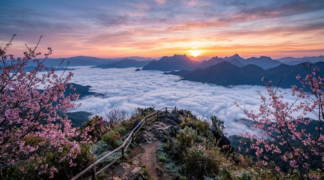
อุทยานแห่งชาติห้วยน้ำดัง • Huai Nam Dang National Park
Declared as Thailand’s 81st national park on August 14, 1995, Huai Nam Dang spans 1,252 sq km across the mountainous border between Chiang Mai and Mae Hong Son provinces. The park sits atop a ridge of highland peaks — the highest being Doi Chang at 1,962 meters — where streams feed the Pai, Ping, and Taeng Rivers.
For medical tourists visiting northern Thailand, Huai Nam Dang offers a unique combination of accessible scenic viewpoints, therapeutic mineral hot springs, and cool mountain air that provides genuine relief from tropical heat. The Doi Kiew Lom sunrise viewpoint — the park’s most famous attraction — requires minimal physical effort, while the Pong Dueat hot springs provide therapeutic mineral soaking in a stunning forest setting.
Important: Park fees, hours, trail conditions, and road conditions are subject to change. Verify current information with the park office before your visit. Weather conditions, wildlife sightings, and mist formations cannot be guaranteed.
Why Huai Nam Dang is Special
Sea of Mist Phenomenon
Doi Kiew Lom viewpoint at approximately 1,600 meters elevation offers one of Thailand’s most spectacular natural phenomena: a sunrise over a vast sea of white mist filling the valleys below, with the jagged peak of Doi Chiang Dao as a dramatic backdrop. During cool season mornings (November–February), cold air settles into the valleys while the ridgetop remains clear, creating an ethereal landscape that has made this one of northern Thailand’s most photographed locations.
Therapeutic Hot Springs
The park contains two significant hot spring complexes:
- Pong Dueat Pa Pae: Thailand’s largest geyser — erupting every 30 seconds, shooting water up to 2 meters high at 99°C. Temperature-controlled mineral bathing pools are available for therapeutic soaking. Scientific studies (Extremophiles journal, 2024) confirmed the silica-rich mineral composition of these waters.
- Tha Pai Hot Spring: Located in the Pai District section of the park, surrounded by teak forest. Entry to Huai Nam Dang also covers same-day entry here.
Wild Himalayan Cherry Blossoms
From December through February (peaking in January), wild Himalayan cherry trees (Prunus cerasoides) bloom across the highland areas, transforming the mountain landscape with delicate pink blossoms — Thailand’s closest equivalent to Japan’s cherry blossom season.
Natural Features & Ecology
Landscape and Geography
The park encompasses a series of high mountain ridges and deep valleys at elevations ranging from 400 meters to 1,962 meters (Doi Chang summit). The terrain transitions from mixed deciduous forests in the lower valleys to pine forests and highland meadows at upper elevations.
Forest Types
| Forest Type | Elevation | Notable Features |
|---|---|---|
| Mixed deciduous | Lower slopes | Teak, padauk, diverse hardwoods |
| Deciduous dipterocarp | Mid-elevations | Shorea species, seasonal leaf drop |
| Evergreen | Mid to upper slopes | Year-round canopy, orchids |
| Pine forest | Higher elevations | Pinus merkusii, Pinus kesiya |
| Deciduous bamboo | Valley floors | Dense bamboo groves |
Flora Highlights
Notable plant species include teak (Tectona grandis), Burma padauk (Pterocarpus macrocarpus), Sumatran pine (Pinus merkusii), Khasi pine (Pinus kesiya), and indigenous rare Lady Slipper Orchid (Paphiopedilum sp.). Wild Himalayan cherry (Prunus cerasoides) blooms December–February.
Wildlife
The park supports diverse fauna including Asian elephant, sambar deer, Asiatic black bear, barking deer, macaques, langur, gibbon, goral, Asiatic wild dog (dhole), and flying squirrel. Over 260 bird species have been recorded, including Thick-billed Green Pigeon, Hill Myna, Red Junglefowl, Blue Magpie, and various kingfisher species along the Mae Taeng River.
Note: Wildlife sightings are never guaranteed. The park covers 1,252 sq km and animals roam freely. Binoculars are essential for birdwatching.
Activities & Experiences
Activity Suitability Overview
| Activity | Difficulty | Duration | Post-Surgery Suitability |
|---|---|---|---|
| Doi Kiew Lom sunrise | Easy | 1–2 hours | Suitable for most recovery stages; early wake-up required |
| Pong Dueat hot spring soaking | Easy | 1–2 hours | Excellent for relaxation; check with doctor for wound immersion |
| Pong Dueat nature trail | Easy | 45–60 min | Suitable from Week 2+ |
| Scenic driving | Easy | Variable | Suitable from Week 1+ |
| Bamboo rafting (Mae Taeng) | Low-moderate | 3–4 hours | Generally suitable Week 2+; some effort getting on/off raft |
| Huai Nam Dang Waterfall | Moderate | 2–3 hours | Moderate recovery only; uneven terrain |
| Mae Yen Waterfall hike | Moderate-challenging | 5–7 hours | Not suitable for early recovery |
| Stargazing | Easy | Variable | Suitable for all recovery stages |
Water Activities
- Bamboo rafting on Mae Taeng River: 3–4 hours from Ban Pang Pa Kha to Ban Sop Kai. Life jackets mandatory. May be cancelled during heavy rain. Considered the best bamboo rafting in northern Thailand.
- Swimming at Mae Yen Waterfall: Deep pool available at the waterfall (requires 17 km round-trip hike).
- Therapeutic mineral bathing: Temperature-controlled pools at Pong Dueat hot spring.
Photography
| Location | Subject | Best Time |
|---|---|---|
| Doi Kiew Lom | Sunrise, sea of mist, Doi Chiang Dao | 05:00–07:00 AM (Nov–Feb) |
| Doi Chang | 360° mountain panoramas | Early morning |
| Pong Dueat | Erupting geyser | Any time |
| Highland areas | Cherry blossoms | January |
| Pine meadows | Landscape, wildflowers | Oct–Feb |
Camping
Designated camping grounds are available with bathroom and shower facilities. Tents can be rented from the park office (approximately 225–250 THB for 2–3 person tent) or bring your own (approximately 30–60 THB per night). Sleeping bags, pillows, mats, and cooking utensils are also available for rent. Book via the DNP online booking system up to 60 days in advance.
Note: December–January peak season can be fully booked. Bring warm sleeping gear — temperatures drop near freezing.
Stargazing
The park’s high elevation and minimal light pollution make it excellent for stargazing and astrophotography. Best during cool season with clear skies. This is a zero-impact relaxation activity suitable for all recovery stages.
Cultural Experiences
Guided treks can include visits to Karen, Hmong, Lahu, Lisu, and Akha hill tribe villages within the park boundaries. These communities maintain traditional lifestyles with solar-only power and no road construction permitted within villages.
Trail Guide
Trail Overview
| Trail | Distance | Difficulty | Time | Guide Required |
|---|---|---|---|---|
| Pong Dueat Nature Trail | 1.55 km | Easy | 45–60 min | No |
| Mae Yen Waterfall Trail | 17.2 km round trip | Moderate | 5–7 hours | No (recommended) |
| Ban Mae Sae Trail | Not verified | Easy-moderate | Not verified | Recommended |
| Doi Chang | 20 km from Doi Kiew Lom | Challenging | 4WD required | Required |
Pong Dueat Nature Trail
- Distance: 1.55 km
- Difficulty: Easy
- Elevation gain: Minimal
- Surface: Maintained boardwalk and trail
- Shade: Forested throughout
- Time: 45–60 minutes
- Highlights: Starts at Pong Dueat hot spring geyser. Nature interpretation trail through woodland with signage identifying flora.
Mae Yen Waterfall Trail
- Distance: 17.2 km (10.7 miles) round trip
- Difficulty: Moderate
- Elevation gain: 752 m (2,467 ft)
- Surface: Forest trail, rice field paths, river crossings
- Shade: Mostly shaded through forest
- Time: 5–7 hours
- Highlights: Lush forest, rice paddies, hill tribe villages. Swimming possible at waterfall. Rated 4.5 stars on AllTrails (304 reviews).
Warning: River crossings can be dangerous during rainy season. A hiking stick is recommended. This trail is not suitable for patients in early recovery.
Doi Chang
- Elevation: 1,962 m (highest point in the park)
- Access: 4WD vehicle required — 20 km from Doi Kiew Lom on unpaved mountain road
- Guide: Required
- Notes: Check road conditions with rangers before attempting. No hiking trail — accessible by 4WD only.
For Medical Tourists
Physical Requirements Assessment
| Factor | Level | Details |
|---|---|---|
| Walking Distance | Variable | 0 km (viewpoint by car) to 17+ km (Mae Yen trail) |
| Elevation | 400–1,962 m | Cool temperatures; not typically high enough for altitude sickness |
| Temperature (cool season) | 2–20°C | Significantly cooler than Bangkok; cold can affect cardiovascular recovery |
| Shade | Good on forest trails | Limited at viewpoints and camping areas |
| Rest Areas | Moderate | Shelters at viewpoints; facilities at visitor center |
| Mobile Signal | Limited | Available near headquarters; unreliable elsewhere |
Recovery Week Recommendations
| Activity | Difficulty | Earliest Safe | Ideal Week | Key Considerations |
|---|---|---|---|---|
| Doi Kiew Lom sunrise | Easy | Week 1 | Week 1+ | Short walk from parking; early wake-up; bring warm layers |
| Scenic driving | Easy | Week 1 | Week 1+ | Mountain roads are winding (762+ curves on Hwy 1095) |
| Pong Dueat hot spring soaking | Easy | Week 2 | Week 2+ | Check with doctor before immersing surgical wounds |
| Pong Dueat nature trail (1.55 km) | Easy | Week 2 | Week 2+ | Flat, maintained, forested |
| Bamboo rafting | Low-moderate | Week 2 | Week 2+ | Passive activity; some effort boarding raft |
| Cherry blossom viewing | Easy | Week 1 | Week 1+ | Vehicle-accessible viewpoints available |
| Stargazing | Easy | Week 1 | Week 1+ | Zero physical exertion |
| Huai Nam Dang Waterfall | Moderate | Week 3 | Week 3+ | Uneven terrain; moderate walking |
| Mae Yen Waterfall hike | Challenging | N/A | N/A | Not recommended during recovery |
| Multi-day treks | Challenging | N/A | N/A | Not recommended during recovery |
Procedure-Specific Guidance
| Procedure Type | Earliest Visit | Recommended Activities |
|---|---|---|
| Dental (simple) | Week 1 | Sunrise viewpoint, scenic drives, stargazing |
| Minor cosmetic | Week 1 | Viewpoint, hot spring soaking (Week 2, doctor approval) |
| LASIK | Week 2 | All easy activities; bring UV-protective sunglasses |
| Orthopedic (minor) | Week 2 | Vehicle-based only; avoid uneven trails |
| Abdominal surgery | Week 2 | Viewpoint, hot spring soaking with doctor approval |
| Cardiac procedures | Week 3+ | Consult cardiologist — cold temperatures (2°C) are medically significant |
| Major orthopedic | Week 4+ | Doctor approval required — trails not recommended |
Medical Advisory: Consult your treating physician before outdoor activities post-surgery. The park’s remote location means the nearest hospital (Pai Hospital) is approximately 45 km away on winding mountain roads (approximately 1 hour drive). Cold temperatures near freezing can be dangerous for cardiac patients. Do not immerse surgical wounds in hot spring water without doctor approval.
Nearest Hospitals
| Hospital | Distance | Travel Time | Type | Key Services |
|---|---|---|---|---|
| Pai Hospital | ~45 km | ~1 hour | Government | Emergency, outpatient, inpatient; 40 beds; English-speaking staff |
| Mae Taeng Hospital | ~50 km | ~1–1.5 hours | Government | General hospital |
| Nakornping Hospital | ~80 km | ~2 hours | Government (regional) | Major regional hospital; Mae Rim District |
| Bangkok Hospital Chiang Mai | ~80–90 km | ~2–2.5 hours | Private (international) | Full ICU, English-speaking staff |
Emergency Contacts:
- National Emergency/Ambulance: 1669
- Tourist Police: 1155
- Park Office: +66 5326 3910 / +66 5326 3911
Key Medical Tourist Warnings
- Cold temperatures (near freezing in cool season) can be dangerous for cardiac patients
- Remote location — nearest hospital 45+ km on winding mountain roads
- Mobile phone signal unreliable — carry a satellite communicator if possible for extended hikes
- Do not immerse surgical wounds in hot spring water without doctor approval
- Smoky season (March–May) — poor air quality dangerous for respiratory patients; avoid visiting
- Altitude up to 1,962 m — cardiac and respiratory patients should be aware of reduced oxygen
Getting There
From Bangkok
Fly to Chiang Mai International Airport (CNX) — approximately 1 hour 15 minutes, multiple daily flights. Then drive 2–2.5 hours north.
From Chiang Mai by Car (Recommended)
| Detail | Information |
|---|---|
| Distance | ~70 km to park |
| Duration | 2–2.5 hours |
| Route | Highway 107 north ~37 km to Mae Malai, then Highway 1095 toward Pai ~65 km to park checkpoint |
| Road Condition | Highway 1095 is well-maintained but extremely winding (762+ curves) |
From Highway 1095: At Km 65–66, turn right and drive 6 km to park headquarters. No public transport for this last section.
From Pai
| Detail | Information |
|---|---|
| Distance | ~40 km |
| Duration | ~1 hour by car/motorbike |
| Route | Highway 1095 eastbound |
By Public Transport
From Chiang Mai Bus Terminal 3 (Arcade), take a Chiang Mai–Pai minibus and ask to be dropped at Km 65–66 on Highway 1095. Then arrange local transport for the remaining 6 km to park headquarters — hitchhiking or pre-arranged transport required as no public transport covers this section.
Road Conditions Warning
Highway 1095 has 762+ winding curves. Internal park roads can be narrow, poorly maintained with potholes and loose gravel. 4WD is recommended for the Doi Chang area and during rainy season. Drive carefully and allow extra time.
Parking
Available at park headquarters and viewpoints. Vehicle entrance fee: car 30 THB, motorbike 20 THB.
Accommodation
Inside the Park
Bungalows: Cabin-style accommodation for up to 8 guests in dorm-like settings. Must book at least 2 days in advance through the DNP booking system.
Camping: Multiple designated camping zones, each with bathroom facilities. Tents, sleeping bags, pillows, mats, and cooking utensils available for rent.
Booking: DNP online booking system (nps.dnp.go.th) or phone +66 2562 0760. Payment within 2 days of booking or auto-cancelled. International visitors transfer fees to Krung Thai Bank.
Prices subject to change. DNP accommodation pricing is updated periodically. Verify current rates on the booking system.
Nearby Options
- Pai town (~1 hour west): Wide range from budget guesthouses to boutique resorts — the most comfortable option with the best dining and medical facilities nearby
- Mae Taeng town (~1 hour south): Limited but available accommodation
- Karen village homestays: Available through authorized operators within the park area
Tip: For comfort, stay in Pai and visit the park for sunrise as a day trip (requires very early departure around 04:00 AM).
Practical Tips
What to Pack
Essential:
- Warm layers, hat, and gloves (cool season mornings can reach 2°C)
- Sturdy footwear with good grip
- Water (minimum 1.5L per person)
- Sunscreen and sunglasses (strong UV at elevation despite cool temperatures)
- Insect repellent
- Flashlight/headlamp (for pre-dawn viewpoint arrival)
- Camera with charged batteries (cold drains batteries faster)
- Cash (THB) — limited services in the park
Rainy Season (May–October):
- Rain jacket and waterproof bag for electronics
- Leech socks (leeches active in rainy season; rare in cool season)
- Change of clothes
- Extra caution on muddy trails
For Recovery Patients:
- Prescribed medications
- Hospital contact card with emergency numbers
- Warm clothing (cold stress affects recovery)
- Comfortable travel pillow for winding road journey
- Electrolyte drinks and light snacks
What NOT to Bring
- Single-use plastics (national park rules)
- Loud speakers or music equipment
- Alcohol (prohibited in some park areas)
Insect and Wildlife Safety
- Leeches: Present during rainy season (May–October), rare in cool season. Wear long pants and leech socks.
- Snakes: Cobra, banded krait, constrictors, and rat snakes inhabit forested areas. Stick to trails, wear boots, and use a flashlight at night.
- Macaques: Common near campsites — secure all food.
- Wild boar: Present in remote areas — keep your distance.
Environmental Responsibility
Leave No Trace
Strictly enforced by park rangers. All waste must be carried out. Fines are imposed for littering.
Park Rules
- No hunting or disturbing wildlife
- No collecting plants, animals, or geological specimens
- No open fires outside designated areas
- No loud music
- Stay on marked trails
Ethical Wildlife Guidelines
- No feeding wild animals — disrupts natural behavior
- No elephant riding — no longer offered in the park area
- Maintain distance from all wildlife
- Do not approach or touch macaques
- Report injured wildlife to rangers
Community Tourism
Karen, Hmong, Lahu, Lisu, and Akha hill tribe villages within park boundaries maintain traditional lifestyles. These villages operate with solar-only power and no road construction is permitted. Visit only through authorized guided treks that respect community autonomy.
Seasonal Guide
Month-by-Month Conditions
| Month | Weather | Temperature | Medical Tourist Rating |
|---|---|---|---|
| January | Coldest, driest | 2–18°C | Excellent — peak mist, cherry blossoms |
| February | Cool, dry | 5–22°C | Excellent — good mist, less crowded |
| March | Warming, smoke begins | 12–28°C | Not recommended (burning season) |
| April | Hot, smoky peak | 15–30°C | Not recommended (worst air quality) |
| May | Rain begins, smoke clears | Warming | Fair — landscapes greening, leeches |
| June | Rainy season | 10–24°C | Not recommended (muddy trails) |
| July | Heavy rain | 10–24°C | Not recommended |
| August | Wettest month | 10–24°C | Not recommended |
| September | Still rainy | 10–24°C | Not recommended |
| October | Rain decreasing | Cooling | Fair — early mist forming |
| November | Cool season begins | 8–22°C | Excellent — mist forming, cherry starting |
| December | Peak season | 3–20°C | Excellent — mist, cherry blossoms, cold |
Best Months for Specific Activities
| Activity | Best Months | Notes |
|---|---|---|
| Sea of mist (sunrise) | Nov–Feb | Most frequent in January; arrive before 05:30 |
| Cherry blossoms | Dec–Feb | Peak in January |
| Hiking | Nov–Feb | Dry trails, comfortable temperatures |
| Birdwatching | Nov–Feb | Peak bird activity; early morning best |
| Hot spring soaking | Year-round | Especially pleasant in cool season |
| Photography | Nov–Feb | Clear skies, mist, blossoms |
| Bamboo rafting | Nov–Feb | Best water levels; may be cancelled during heavy rain |
Seasonal Warnings
Burning/Smoky Season (March–May):
- Field burning causes severe air quality degradation
- Haze obscures views and can trigger respiratory problems
- Dangerous for patients with respiratory conditions — avoid visiting entirely
Monsoon Season (June–October):
- Trails muddy and slippery
- Leeches active
- Some roads difficult — 4WD recommended
- Flash flooding possible on mountain roads
- Beautiful green scenery; very few tourists
Key Attractions Detail
Doi Kiew Lom Viewpoint
The park’s most famous attraction — a panoramic sunrise viewpoint over a sea of mist with Doi Chiang Dao as backdrop.
| Detail | Information |
|---|---|
| Elevation | ~1,600 m |
| Access | Paved road to parking, short walk to platform |
| Best Time | 05:00–07:00 AM (Nov–Feb) |
| Difficulty | Easy |
Tips: Arrive by 05:00–05:30 for best position. Can be extremely crowded on weekends during peak season. Bring warm clothes, flashlight, and camera. Sunset is also visible from this viewpoint.
Pong Dueat Pa Pae Hot Spring
Thailand’s largest geyser — erupts every 30 seconds, shooting water up to 2 meters at 99°C.
| Detail | Information |
|---|---|
| Location | Km 42 on Highway 1095, before park entrance |
| Access | Easy access from highway |
| Facilities | Mineral bathing pools, 1.55 km nature trail, changing areas |
| Therapeutic Value | Silica-rich mineral water in temperature-controlled pools |
Doi Chang
The park’s highest point at 1,962 meters with 360° mountain panoramas and sea of cloud views.
| Detail | Information |
|---|---|
| Access | 4WD vehicle required; 20 km from Doi Kiew Lom |
| Guide | Required |
| Best Time | Early morning |
Warning: Only accessible by 4WD on unpaved mountain road. Check conditions with rangers before attempting.
Nearby Attractions
Nature Sites
| Attraction | Distance | Description |
|---|---|---|
| Doi Luang Chiang Dao | ~40 km | Thailand’s 3rd highest mountain; UNESCO Biosphere Reserve |
| Chiang Dao Cave Temple | ~40 km | Buddhist cave temple complex |
| Pai Canyon (Kong Lan) | ~40 km west | Scenic canyon viewpoint near Pai |
| Pha Daeng National Park | ~50 km | Sticky waterfall; Pong Arng Hot Springs |
Cultural Sites
| Attraction | Distance | Description |
|---|---|---|
| Pai Walking Street | ~40 km west | Night market with local food and crafts |
| Wat Phra That Mae Yen | Near Pai | Hilltop Big Buddha temple |
| Baan Santichon | Near Pai | Chinese Yunnan village |
| Wat Ban Den | Mae Taeng | Remarkable Buddhist temple complex |
| Pai Memorial Bridge | Near Pai | WWII historical site |
Hot Springs in the Region
- Pong Dueat Pa Pae (within park) — geyser and therapeutic pools
- Tha Pai Hot Spring (within park, Pai section) — forest setting
- Pong Arng Hot Spring (Pha Daeng National Park, ~50 km)
- San Kamphaeng Hot Springs (~130 km, near Chiang Mai)
Food and Markets
Limited food options within the park (basic food stalls near headquarters). Pai town has extensive dining options including Thai, international, and vegetarian restaurants. Pai Night Market operates daily with local food and crafts.
Guided Tours
Multi-Day Treks
Green Trails (www.green-trails.com):
- 2-day trek from 7,700 THB
- 3-day trek with bamboo rafting from 9,900 THB
- 4-day expedition available
- Includes guide, meals, Karen homestay accommodation, bamboo rafting
- No elephant riding offered (ethical operator)
Bamboo Rafting
| Detail | Information |
|---|---|
| Route | Ban Pang Pa Kha to Ban Sop Kai on Mae Taeng River |
| Duration | 3–4 hours |
| Safety | Life jackets mandatory |
| Availability | May be cancelled during heavy rain |
Prices are approximate and subject to change. Verify current rates with operators before booking.
Visitor Information
Entry Fees
| Visitor Type | Fee |
|---|---|
| Foreign adult | 300 THB |
| Foreign child | 150 THB |
| Thai adult | 50 THB |
| Thai child | 20 THB |
| Vehicle (car) | 30 THB |
| Vehicle (motorbike) | 20 THB |
Notes:
- Entrance ticket also valid for Tha Pai Hot Spring on the same day
- Payment accepted in cash; DNP online booking for accommodation
- Pong Dueat hot spring is at Km 42 on Highway 1095 (before the main park entrance)
Prices subject to change without notice. Verify current fees at the park entrance or DNP website.
Park Office Contact
- Phone: +66 5326 3910 / +66 5326 3911
- DNP Booking: nps.dnp.go.th / +66 2562 0760
- Park Hours: 08:00–18:00 daily (sunrise visitors typically arrive before official opening for Doi Kiew Lom)
Safety Summary
- Cold: Temperatures can reach 2°C — bring warm layers; cold is medically significant for cardiac patients
- Roads: Highway 1095 has 762+ curves; internal roads are narrow with potholes and no guardrails
- Trails: Stick to marked paths; slippery in rainy season; carry water and sun protection
- Wildlife: Maintain safe distance; secure food from macaques; snakes present in forested areas
- Communication: Limited mobile signal; download offline maps; carry emergency contacts on paper
- Medical: Nearest hospital (Pai) is ~1 hour away on winding roads
- Air Quality: Avoid March–May due to burning season — dangerous for respiratory patients
- Hot Springs: Do not immerse recent surgical wounds without doctor approval; water temperature can cause burns near the geyser
Disclaimer: Outdoor activities involve inherent risks. Weather conditions, trail conditions, road conditions, and wildlife behavior are unpredictable. Medical tourists should consult their physician before visiting. Park fees, hours, and regulations may change without notice. Wildlife sightings cannot be guaranteed. The information in this guide is provided for general reference and may not reflect the most current conditions.
Frequently Asked Questions
Is Huai Nam Dang safe to visit after surgery?
Yes, with appropriate activity selection. The Doi Kiew Lom sunrise viewpoint requires only a short walk from the car park and is suitable from Week 1 post-procedure. Pong Dueat hot spring soaking is suitable from Week 2 for most patients, though immersion in mineral water requires doctor approval for those with recent surgical wounds. Longer hikes like Mae Yen Waterfall (17 km) are not recommended during recovery. Always consult your doctor before outdoor activities post-surgery.
How physically demanding is a visit?
It depends entirely on which activities you choose. Watching sunrise at Doi Kiew Lom is easy — a short walk from parking. The Pong Dueat nature trail is 1.55 km on maintained paths. Mae Yen Waterfall is a challenging 17 km round trip with river crossings. Choose activities that match your fitness level.
Is there mobile phone signal for emergencies?
Mobile signal is limited. Coverage is generally available near park headquarters and the visitor center, but unreliable or absent in remote areas, valleys, and on trails. Do not rely on your phone for navigation or emergency communication in remote sections. Consider carrying a satellite communicator for extended hikes.
Can I visit during the rainy season?
The park is open year-round, but May through October brings heavy rain. Trails become muddy, some roads may be difficult, and leeches are active. The scenery is lush and green, and visitor numbers are low. March through May is not recommended due to burning season with poor air quality.
Are guides required for hiking?
Guides are not required for the main trails including the Pong Dueat nature trail and Mae Yen Waterfall trail. However, guides are required for the Doi Chang area (4WD access only) and are recommended for multi-day treks and remote areas. Guides can be arranged through tour operators in Chiang Mai or Pai.
What is the best time to see the sea of mist?
The sea of mist at Doi Kiew Lom viewpoint is most frequent during the cool season, November through February. January is the peak month. Arrive by 05:00-05:30 AM for the best position. Conditions vary daily — mist formation depends on temperature and humidity.
Can I combine this with a trip to Pai?
Huai Nam Dang sits on Highway 1095 between Chiang Mai and Pai, making it a natural stop on the route. The park is approximately 1 hour from Pai by car. Many visitors stay in Pai and drive to the park for sunrise, departing around 04:00 AM.
How cold does it get?
Temperatures can drop to 2°C during cool season mornings (December-January). Bring warm layers, a hat, and gloves if visiting for sunrise. Daytime temperatures are milder at 15-20°C. The cold can be medically significant for cardiac patients.
Need Help Planning Your Visit?
Our team can help coordinate your visit to Huai Nam Dang National Park during your stay in Thailand.
Check your insurance coverage before booking your medical trip.