Doi Inthanon National Park
Overview
อุทยานแห่งชาติดอยอินทนนท์ • Doi Inthanon National Park
Rising to 2,565 meters, Doi Inthanon is the highest point in Thailand—a mountain whose summit approaches temperate conditions while tropical forests clothe its lower slopes. Established as Thailand’s sixth national park in 1972, this 482 sq km sanctuary protects one of Southeast Asia’s most biodiverse cloud forests, home to over 400 bird species and endemic flora found nowhere else on Earth.
For medical tourists recovering from procedures in Chiang Mai, Doi Inthanon offers a therapeutic escape to cool mountain air. Summit temperatures average 10-15°C year-round—a welcome respite from the lowland heat. Vehicle-accessible attractions including the Twin Pagodas, multiple waterfalls, and the summit stupa require minimal walking, while the Ang Ka boardwalk provides gentle forest immersion for recovering patients.
Important: Park fees, hours, and trail conditions are subject to change. Verify current information with park headquarters before your visit. Weather conditions are unpredictable at high elevation.
Why Doi Inthanon is Special
Thailand’s Rooftop
At 2,565 meters, Doi Inthanon’s summit marks the highest point in the Kingdom. The peak is named after King Inthawichayanon (1870-1897), the last independent ruler of Chiang Mai, who understood the forests’ importance to the region’s water supply. His ashes are enshrined in a stupa at the summit—a pilgrimage site blending conservation with royal history.
The mountain’s significance:
- Highest peak in Thailand at 2,565 meters
- Thanon Thong Chai Range — part of the Himalayan mountain system extending into Southeast Asia
- Watershed protection — source of the Mae Klang and Mae Chaem rivers
- Cultural heritage — sacred mountain for Chiang Mai’s last independent rulers
Exceptional Biodiversity
Doi Inthanon ranks as Thailand’s second-best national park for bird diversity, with 382-400+ species recorded. The summit’s cloud forest hosts species found nowhere else in Thailand, including the Ashy-throated Warbler and an endemic subspecies of Green-tailed Sunbird.
Conservation highlights:
- 382-400+ bird species — second highest among Thai national parks
- 2 Thai-endemic bird subspecies at summit elevations
- Sphagnum bogs — rare in tropical Southeast Asia
- Wild Himalayan orchids and rhododendrons — temperate flora at tropical latitude
Cloud Forest Ecosystem
The park spans five distinct forest types across its 800m to 2,565m elevation range:
| Elevation Zone | Forest Type | Notable Features |
|---|---|---|
| 800-1,000m | Mixed deciduous | Teak, bamboo groves |
| 1,000-1,500m | Tropical evergreen | Gibbons, hornbills |
| 1,500-1,800m | Pine-oak forest | Rhododendrons, wild cherry |
| 1,800-2,400m | Montane cloud forest | Orchids, mosses, ferns |
| 2,400-2,565m | Summit cloud forest | Sphagnum bogs, endemic species |
Wildlife & Nature
What You Might See
Wildlife at Doi Inthanon is best observed early morning or late afternoon. The park’s dense forest makes animal sightings less frequent than open savanna parks, but the birdlife is exceptional.
| Animal | Best Time | Best Location | Likelihood |
|---|---|---|---|
| White-handed Gibbon | Early morning (calls) | Lower forest trails | Moderate |
| Barking Deer | Dawn, dusk | Forest edges, Kew Mae Pan | Moderate |
| Assam Macaque | Daytime | Near visitor facilities | Good |
| Giant Squirrels | Daytime | Forest canopy, Ang Ka | Good |
| Serow (goat-antelope) | Early morning | Kew Mae Pan cliffs | Low |
| Clouded Leopard | Night | Dense forest | Rare (secretive) |
| Wild Boar | Dawn, dusk | Lower elevation trails | Low-Moderate |
Note: Wildlife sightings are never guaranteed. Animals roam freely across 482 sq km of protected forest. Maintain safe distances and never feed wildlife.
Bird Watching
With 382-400+ species, Doi Inthanon is among Thailand’s premier birdwatching destinations—particularly for montane specialists found only at high elevations.
Summit Specialties (above 1,800m):
- Ashy-throated Warbler (Thailand endemic population)
- Green-tailed Sunbird (endemic subspecies)
- Himalayan Shortwing
- White-gorgetted Flycatcher
- Chestnut-tailed Minla
Notable Species Throughout Park:
- Green Cochoa
- Rufous-throated Partridge
- Silver-eared Mesia
- Mrs. Gould’s Sunbird
- Various bulbuls, warblers, and flycatchers
Best Birdwatching Locations:
- Ang Ka Trail: Summit cloud forest species
- Kew Mae Pan Trail: Montane specialists, excellent dawn chorus
- Pha Dok Siew Trail: Mid-elevation diversity, mixed forest species
- Km 31 (Royal Project): Open areas, feeding stations
Best Periods:
- Year-round for resident montane species
- November-February for visiting Himalayan species
- Early morning (5:30-8:00 AM) for peak activity
Flora Highlights
The park protects rare temperate flora at tropical latitude:
Wild Orchids (January-April peak):
- Dendrobium venustum
- Oberonia species
- Inthanon Lady’s Slipper (conservation program)
Seasonal Blooms:
- Thai Sakura (Prunus cerasoides): Mid-December to mid-January
- Rhododendrons: Late January to mid-February
- Wild orchids: January-April and rainy season species
Unique Habitats:
- Sphagnum moss bogs at summit (extremely rare in tropics)
- Moss-draped cloud forest on Ang Ka Trail
- Highland Arabica coffee plantations (Royal Project)
Waterfalls
Mae Ya Waterfall
Thailand’s second-largest waterfall at 250 meters, cascading over a dramatic cliff face.
| Detail | Information |
|---|---|
| Height | 250m (multi-tiered cascade) |
| Distance from Visitor Center | Access via separate road (20 km southwest) |
| Trail Length | 300m walk from parking |
| Difficulty | Easy |
| Swimming | Partial access, seasonal |
| Best Season | Monsoon and post-monsoon (June-November) for maximum flow |
Tip: Arrive by 7:30 AM for best photography light and fewer crowds.
Wachirathan Waterfall
The park’s most accessible major waterfall at 70-100 meters, with dramatic mist spray.
| Detail | Information |
|---|---|
| Height | 70-100m |
| Distance from Park Entrance | 21 km along Highway 1009 |
| Trail Length | 50m from parking |
| Difficulty | Easy |
| Swimming | Prohibited — slippery rocks, strong currents |
| Best Season | Year-round; most powerful June-November |
Warning: The rocks are extremely slippery. Stay behind barriers. Deaths have occurred from falls.
Sirithan Waterfall
Named after Queen Sirikit, this 50-meter cascade is one of the most photogenic.
| Detail | Information |
|---|---|
| Height | 50m |
| Distance from Park Entrance | 10 km along Highway 1009 |
| Trail Length | Short walk from parking |
| Difficulty | Easy |
| Swimming | Prohibited |
Mae Klang Waterfall
A 100-meter tiered waterfall popular with locals, offering swimming opportunities.
| Detail | Information |
|---|---|
| Height | 100m (tiered) |
| Location | Near park entrance |
| Trail Length | 200m walk |
| Difficulty | Easy |
| Swimming | Permitted (seasonal, check conditions) |
Siriphum Waterfall
Scenic cascade near the Twin Pagodas area.
| Detail | Information |
|---|---|
| Location | Near Km 31 Royal Project |
| Access | Short walk from road |
| Best For | Photography, brief stop |
Hiking Trails
Trail Overview
| Trail | Distance | Time | Guide | Medical Tourist Suitability |
|---|---|---|---|---|
| Ang Ka Nature Trail | 1 km loop | 30-60 min | No | Yes — Week 2+ |
| Kew Mae Pan Nature Trail | 2.8 km loop | 1.5-3 hr | Yes (200 THB) | Week 4+ only |
| Pha Dok Siew Nature Trail | 5.3 km | 2-2.5 hr | Yes (220 THB) | Not recommended |
Ang Ka Nature Trail (Recommended for Recovery)
The most suitable trail for recovering medical tourists.
- Distance: ~1 km circular loop
- Difficulty: Easy
- Elevation: ~2,500m (near summit)
- Time: 30-60 minutes
- Surface: Elevated wooden boardwalk
- Guide Required: No (self-guided, free)
- Open: Year-round
Highlights:
- Pristine cloud forest with moss-covered trees
- Rare sphagnum bogs (boardwalk passes through)
- Excellent low-impact birdwatching
- Atmospheric mist and filtered light
Medical Tourist Notes:
- Boardwalk is mostly accessible but has some uneven sections
- Cool temperatures (bring layers)
- Minimal physical exertion
- Benches available for rest
- Altitude: 2,500m may affect those with respiratory conditions
Kew Mae Pan Nature Trail
Thailand’s premier highland trail for its “sea of clouds” sunrise views.
- Distance: 2.8 km loop
- Difficulty: Moderate
- Elevation: ~2,000m
- Time: 1.5-3 hours
- Surface: Forest path, stairs, boardwalks
- Guide Required: Yes — 200 THB per group (Hmong community guides)
- Open: November 1 - May 31 only (closed June-October for forest restoration)
- Last Entry: 4:00 PM
Highlights:
- “Sea of clouds” at Station 9 viewpoint (best at sunrise)
- Panoramic valley views
- Montane cloud forest ecosystem
- Rare birds including summit specialists
- Sunrise photography opportunities
Physical Requirements:
- Significant stairs throughout
- Uneven terrain with roots and rocks
- 2+ hours of continuous walking
- Elevation may cause breathlessness
Not recommended for recent surgery patients. Stairs and elevation make this unsuitable for recovery. Wait until fully healed and consult your doctor.
Pha Dok Siew Nature Trail
A descending trail through bamboo groves and rice terraces to a multi-tiered waterfall.
- Distance: 5.3 km
- Difficulty: Moderate
- Elevation: Descends from ~1,400m
- Time: 2-2.5 hours
- Surface: Forest path, bridges, stairs, rice terraces
- Guide Required: Yes — 220 THB per group (Karen village guides)
- Open: Year-round (may close during heavy rain)
Highlights:
- Multi-tiered Pha Dok Siew Waterfall
- Bamboo groves and rice terraces
- Karen village of Ban Mae Klang Luang
- Coffee tasting at community café
- Cultural immersion with hill tribe communities
Physical Requirements:
- Sustained descent with stairs
- Uneven forest terrain
- River crossings on bridges
- Return transport arranged at end (trail is one-way)
Not recommended during recovery. Continuous descent stresses knees and requires good balance.
Hiking Gear Recommendations
Essential:
- Long pants (protection from brush)
- Sturdy hiking shoes with grip
- Warm layers (temperatures 5-15°C)
- Rain jacket (weather changes quickly)
- Water (minimum 1L)
- Snacks for energy
For Higher Trails:
- Fleece or down jacket
- Hat and gloves (December-January)
- Sunscreen (thinner atmosphere at altitude)
- Camera with extra batteries (cold drains batteries)
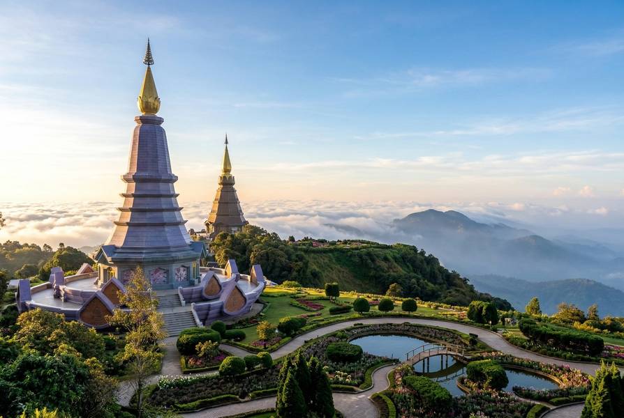
Twin Pagodas & Summit
Phra Mahathat Naphamethanidon & Naphaphonphumisiri
The iconic Twin Pagodas (Naphamethanidon and Naphaphonphumisiri) were built by the Royal Thai Air Force to honor King Bhumibol’s and Queen Sirikit’s 60th birthdays in 1987 and 1992.
| Detail | Information |
|---|---|
| Elevation | ~2,500m |
| Entry Fee | 100 THB per person (separate from park fee) |
| Payment | Cash only |
| Opening Hours | 6:00 AM - 5:30 PM |
| Walking Required | Gardens are walkable; main viewpoint requires stairs |
What to See:
- Ornate stupa architecture blending Thai and Lanna styles
- Spectacular gardens with seasonal flowers
- Panoramic mountain views (best on clear mornings)
- Buddha relics enshrined within pagodas
- Sunrise photography (arrive before 6:30 AM)
Accessibility Note: The middle platform is accessible, but the main viewing terrace at the top requires climbing stairs. Those with mobility limitations should set realistic expectations.
Summit Stupa (King Inthawichayanon Shrine)
The actual summit at 2,565m features a small stupa containing the ashes of King Inthawichayanon.
| Detail | Information |
|---|---|
| Elevation | 2,565m (Thailand’s highest point) |
| Entry Fee | Included in park admission |
| Walking Required | 2-minute walk up concrete steps and boardwalk |
What to See:
- Thailand’s highest point marker
- Memorial stupa with royal history
- Atmospheric cloud forest setting
- Summit selfie opportunity
Note: The summit itself is forested with no panoramic views—the pagodas offer better vistas.
Royal Project Visits
Khun Wang Royal Agricultural Research Centre
The Royal Project demonstrates sustainable highland agriculture, replacing former opium fields with legal crops.
| Detail | Information |
|---|---|
| Location | Km 31 on Highway 1009 |
| Elevation | 1,280-1,380m |
| Hours | 8:00 AM - 4:00 PM daily |
| Entry | Free |
Products Available:
- Arabica coffee (beans and fresh roasted)
- Strawberries (November-February)
- Macadamia nuts
- Cold-climate vegetables
- Cut flowers
Activities:
- Self-guided tour through agricultural displays
- Coffee roasting workshops
- Strawberry picking (in season)
- Cherry blossom viewing (December-January)
- Camping and cabin accommodation
Medical Tourist Appeal: Low-exertion activity with coffee shops, restaurants, and gentle walking paths through gardens. Good stop for recovering patients.
Hill Tribe Villages
Doi Inthanon is home to Karen and Hmong communities who partner with the park:
- Karen village (Ban Mae Klang Luang): Manages Pha Dok Siew Trail; offers coffee, local food, and cultural insights
- Hmong community: Provides guides for Kew Mae Pan Trail; runs market stalls with handicrafts
Guide fees go directly to village community development funds, supporting sustainable livelihoods.
Visitor Information
Entry Fees
| Visitor Type | Fee |
|---|---|
| Foreign adult | 300 THB (~$9 USD) |
| Foreign child (3-14) | 150 THB |
| Thai adult (with ID) | 60 THB |
| Thai child | 30 THB |
| Car parking | 30 THB |
| Bicycle parking | 20 THB |
| Twin Pagodas entry | 100 THB (separate, cash only) |
| Kew Mae Pan guide | 200 THB per group |
| Pha Dok Siew guide | 220 THB per group |
Notes:
- Park ticket valid for 5 consecutive days
- Cash preferred; some areas cash only (pagodas)
- Guide fees go directly to local communities
Prices subject to change without notice. Verify current fees at official DNP website before visiting.
Opening Hours
| Service | Hours |
|---|---|
| Park gates | 5:30 AM - 6:30 PM daily |
| Twin Pagodas | 6:00 AM - 5:30 PM |
| Kew Mae Pan Trail | 6:00 AM - 4:00 PM (last entry) |
| Trail closures | Kew Mae Pan closed June 1 - October 31 |
Seasonal Closures
- Kew Mae Pan Trail: Closed June 1 - October 31 annually for forest restoration
- Pha Dok Siew Trail: May close during heavy monsoon rain
- Park: Open year-round; some facilities limited during heavy rain
For Medical Tourists
Physical Requirements Assessment
| Factor | Level | Details |
|---|---|---|
| Walking Distance | Variable | 0 km (driving) to 5.3 km (Pha Dok Siew) |
| Elevation | 800-2,565m | Significant altitude; summit above mild symptom threshold |
| Temperature | 5-25°C | Cool to cold; warm layers essential |
| Shade | Good on trails | Limited at pagodas and viewpoints |
| Rest Areas | Good | Visitor center, pagoda gardens, coffee shops |
| Mobile Signal | Patchy | Good at lower elevations; limited at summit and trails |
Altitude Considerations
The summit at 2,565m is above the 2,400m threshold where mild altitude symptoms can occur:
- Most visitors: Unaffected for day visits
- Sensitive individuals: May experience mild headache, breathlessness
- Cardiac/respiratory conditions: Consult doctor before visiting summit
Mitigation:
- Ascend gradually (stop at waterfalls en route)
- Stay hydrated
- Avoid strenuous activity at summit
- Descend if symptoms worsen
Recovery Week Recommendations
| Activity | Difficulty | Earliest Safe | Ideal Week | Key Considerations |
|---|---|---|---|---|
| Scenic driving | Easy | Week 1 | Week 1+ | No walking; air-conditioned vehicle |
| Waterfall viewpoints | Easy | Week 1 | Week 1+ | 50-300m walks from parking |
| Summit stupa | Easy | Week 1 | Week 1+ | 2-minute walk on boardwalk |
| Twin Pagodas gardens | Easy | Week 1 | Week 2+ | Short walks; main viewpoint requires stairs |
| Royal Project visit | Easy | Week 1 | Week 1+ | Gentle gardens, coffee shops |
| Ang Ka boardwalk | Easy | Week 2 | Week 2-3 | 1 km boardwalk; some uneven sections |
| Kew Mae Pan Trail | Moderate | Week 4+ | Week 4+ | 2.8 km with stairs; doctor approval needed |
| Pha Dok Siew Trail | Moderate | N/A | N/A | Not recommended during recovery |
Procedure-Specific Guidance
| Procedure Type | Earliest Visit | Recommended Activities |
|---|---|---|
| Dental (simple) | Week 1 | Scenic driving, waterfalls, pagodas, Royal Project |
| Dental implant | Week 2 | All vehicle-accessible sites; Ang Ka if comfortable |
| LASIK | Week 2 | All activities; bring sunglasses (bright at altitude) |
| Minor cosmetic | Week 2 | Vehicle-accessible sites; avoid sun exposure at pagodas |
| Rhinoplasty | Week 2 | Vehicle-based only; cold air may cause discomfort |
| Abdominal surgery | Week 3 | Limited walking; scenic driving preferred |
| Orthopedic (minor) | Week 3 | Vehicle-based; avoid uneven trails |
| Cardiac procedures | Week 4+ | Consult cardiologist — altitude and cold are concerns |
| Hip/knee replacement | Week 6+ | Doctor approval required — trails not recommended |
Medical Advisory: The summit elevation (2,565m) and cold temperatures (5-15°C) require consideration for cardiac and respiratory patients. Medical facilities are 1.5-2.5 hours away in Chiang Mai. Consult your treating physician before visiting.
Why Doi Inthanon Suits Medical Tourists
- Cool climate: Summit temperatures 10-15°C vs. lowland 30°C+
- Vehicle-accessible beauty: Major attractions reachable without hiking
- Therapeutic nature: Cloud forests support mental wellness during recovery
- Flexible activity levels: From zero walking to gentle boardwalk trails
- Day trip feasible: 1.5-2 hours from Chiang Mai hospitals
- Quality backup: Chiang Mai Ram Hospital (JCI accredited) ~2 hours away
Nearest Hospitals
| Hospital | Distance | Travel Time | Type | Key Services |
|---|---|---|---|---|
| Chom Thong Hospital | 20-30 km | 30-45 min | Public | Basic emergency, stabilization |
| Chiang Mai Ram Hospital | 70-100 km | 1.5-2.5 hr | Private (JCI) | Full tertiary care, international patients |
| Maharaj Nakorn Chiang Mai | 80-100 km | 1.5-2.5 hr | Public | Comprehensive public hospital |
Emergency Contacts:
- National Emergency: 1669
- Tourist Police: 1155
- Park Headquarters: +66 53 286 729
Getting There
From Chiang Mai by Car (Recommended)
| Detail | Information |
|---|---|
| Distance | 60-100 km (depending on destination in park) |
| Duration | 1.5-2.5 hours |
| Route | Highway 108 south to Chom Thong → Highway 1009 into park |
| Road Condition | Fully paved, well-maintained; winding mountain road (9.5% grade) |
| Drive Time | ~45 minutes from park entrance to summit |
Notes:
- Surface frost possible near summit November-January
- No fuel stations inside park—fill up in Chom Thong
- Rental car from Chiang Mai: 1,000-1,500 THB/day
From Bangkok
| Step | Option | Duration | Cost |
|---|---|---|---|
| Flight | Bangkok → Chiang Mai | 1 hour | 1,500-4,000 THB |
| Ground | Chiang Mai → Park | 1.5-2 hours | Rental car or private transfer |
From Chiang Mai by Public Transport
Step 1: Chiang Mai to Chom Thong
| Option | Details | Duration | Cost |
|---|---|---|---|
| Yellow songthaew | From Chang Phueak Terminal or Pratu Gate | 1-1.5 hours | 20-30 THB |
| Schedule | 8:00 AM - 4:00 PM | — | — |
Step 2: Chom Thong to Park Entrance
| Option | Details | Duration | Cost |
|---|---|---|---|
| Red songthaew/minibus | From Wat Phra That Si Chom Thong | 30-40 min | 140-180 THB |
Critical Limitation: There is NO public transport within the park to reach the summit, Twin Pagodas, or trailheads (20-48 km further). A private vehicle, motorcycle rental, or organized tour is essential for meaningful exploration.
Alternative Transport
| Option | Cost | Notes |
|---|---|---|
| Private car hire from Chiang Mai | 2,500-3,500 THB (full day) | Most convenient; driver waits |
| Motorbike rental from Chiang Mai | 200-250 THB/day | Scenic but steep; experienced riders only |
| Day tour from Chiang Mai | 1,500-3,000 THB | Includes transport, guide, lunch, fees |
Accommodation
Inside the Park
Bungalows (Book via DNP website, 7-60 days in advance):
| Type | Price (THB) | Notes |
|---|---|---|
| Small bungalow | 1,000-1,500 | Basic, fan-cooled |
| Large bungalow | 2,000-6,500 | Multiple rooms |
| Weekday discount | 20% off Mon-Thu | — |
- Facilities: Hot showers, basic but adequate
- Location: Near Ban Luang, 300m from main campground
- Booking: DNP website (http://portal.dnp.go.th)
- Payment: Within 2 days via 7-Eleven or Thai bank transfer
- Note: International visitors may find booking process difficult
Camping:
| Detail | Information |
|---|---|
| Own tent fee | 30 THB per person per night |
| Tent rental | 225 THB (3-person) |
| Sleeping bag rental | 30 THB |
| Sleeping pad | 20 THB |
| Pillow | 10 THB |
Warning: Nights are very cold (near freezing December-January). Bring warm sleeping gear and layers.
Near the Park
| Option | Location | Price Range | Notes |
|---|---|---|---|
| Little Home Inthanon Resort | Near park entrance | $$-$$$ | Convenient access |
| Doiintanon View Resort | Near park entrance | $$-$$$ | Mountain views |
| Mae Chaem Hotel | West entrance | $-$$ | 400-600 THB; basic |
| Khun Wang Royal Project | Km 31 | $$-$$$ | Cabins, camping |
| Hill tribe homestays | Various villages | $ | Authentic; basic facilities |
Staying in Chiang Mai
Advantages:
- Wider accommodation range
- Closer to medical facilities
- Easier booking
- More dining and entertainment
Disadvantage: 1.5-2 hour drive each way; early start needed for sunrise
Seasonal Guide
Month-by-Month Conditions
| Month | Weather | Temperature (Summit) | Rainfall | Medical Tourist Rating |
|---|---|---|---|---|
| January | Cool, clear, peak season | 5-15°C | Very low | Excellent |
| February | Cool, dry, rhododendrons | 8-18°C | Low | Excellent |
| March | Warming, haze possible | 10-22°C | Low-moderate | Good (burning season) |
| April | Hot at lower elevations | 12-24°C | Moderate | Fair (haze, heat) |
| May | Rain begins | 14-22°C | Increasing | Fair |
| June | Rainy, Kew Mae Pan CLOSED | 14-20°C | High | Not recommended |
| July | Peak monsoon | 14-20°C | Heavy | Not recommended |
| August | Heavy rain continues | 14-20°C | Heavy | Not recommended |
| September | Wettest month | 14-20°C | Peak rain | Not recommended |
| October | Rain easing | 12-18°C | Moderate | Fair (late month) |
| November | Dry season begins, Kew Mae Pan OPENS | 8-16°C | Low | Excellent |
| December | Peak season, cherry blossoms | 5-15°C | Very low | Excellent |
Best Months for Specific Activities
| Activity | Best Months | Notes |
|---|---|---|
| Kew Mae Pan Trail | Nov-Feb | Open Nov 1; sea of clouds at sunrise |
| Birdwatching | Nov-Feb | Winter migrants add to diversity |
| Cherry blossoms (Thai Sakura) | Mid-Dec to mid-Jan | Khun Wang Royal Project |
| Rhododendrons | Late Jan to mid-Feb | Higher elevations |
| Wild orchids | Jan-Apr and rainy season | Various species |
| Photography | Nov-Feb | Clear skies, good light |
| Waterfall viewing | Jul-Nov | Maximum water flow |
| Strawberry picking | Nov-Feb | Royal Project |
| Coffee harvest | Nov-Feb | Fresh roasted available |
Seasonal Warnings
Burning Season (March-April):
- Significant haze from agricultural burning
- Reduced visibility for views
- Air quality concerns for respiratory patients
- Not recommended for medical tourists
Rainy Season (June-October):
- Trails muddy and slippery
- Leeches active on forest trails
- Some trails may close
- Kew Mae Pan CLOSED for restoration
- Waterfalls at maximum flow
Cold Season (November-February):
- Near-freezing temperatures at summit
- Surface frost possible on roads
- Warm clothing essential
- Most popular period—book ahead
What to Bring
Essential Items
- Warm clothing: Fleece, jacket, long pants (summit temperatures 5-15°C)
- Layers: Temperature varies 20°C between base and summit
- Sturdy footwear: Hiking shoes with grip for trails
- Rain jacket: Weather changes quickly at altitude
- Sun protection: Sunscreen, sunglasses, hat (thinner atmosphere)
- Water: Minimum 1L per person
- Cash (THB): Park fees, pagoda entry, guides, food
- Offline maps: Download before entry (patchy signal)
For Cold Season (November-February)
- Hat and gloves (summit visits)
- Additional thermal layers
- Hand warmers (optional)
- Warm socks
For Rainy Season (May-October)
- Waterproof jacket and pants
- Leech socks (if hiking forest trails)
- Waterproof bag for electronics
- Quick-dry clothing
- Change of clothes in car
For Recovery Patients
- Prescribed medications
- Hospital contact card with emergency numbers
- Warm layers (cold can cause discomfort post-surgery)
- Comfortable vehicle cushion for winding road
- Light snacks for energy
- Hot drinks (thermoses available at Royal Project café)
Environmental Responsibility
Leave No Trace
Doi Inthanon’s ecosystems are fragile and irreplaceable:
- Pack out all trash — Dispose properly at designated bins
- Stay on marked trails — Protects endemic plants and prevents erosion
- Do not pick flowers or plants — Wild orchids are protected
- No collecting — Rocks, soil, plants, and insects must remain
Park Rules
- No feeding wildlife — Disrupts natural behavior
- No loud music — Disturbs wildlife and other visitors
- No drones without permit — Protected airspace
- No single-use plastic bags — Bring reusable bags
- Respect sacred sites — Pagodas and summit stupa are religious sites
Ethical Wildlife Guidelines
- Maintain distance from all wildlife
- Do not use flash photography on birds
- Do not attempt to attract or corner animals
- Report injured wildlife to rangers
Community Tourism
Doi Inthanon demonstrates responsible community-based tourism:
- Karen village (Ban Mae Klang Luang): Manages Pha Dok Siew Trail; guide fees support community development
- Hmong community: Provides Kew Mae Pan guides; preserves traditional knowledge
- Royal Project: Sustainable agriculture replaced opium cultivation; supports hill tribe livelihoods
By hiring local guides and purchasing from village markets, visitors directly support forest conservation and community welfare.
Nearby Attractions
Within the Park
| Attraction | Distance from Visitor Center | Notes |
|---|---|---|
| Twin Pagodas | ~3 km from summit | Separate 100 THB fee |
| Summit Stupa | At summit (2,565m) | Free with park entry |
| Ang Ka Trail | Near summit | 1 km boardwalk |
| Royal Project | Km 31 | Free entry; coffee, gardens |
| Various waterfalls | 10-22 km from entrance | Multiple stops possible |
Outside the Park
| Attraction | Distance | Description |
|---|---|---|
| Wat Phra That Si Chom Thong | At park gateway | Important Lanna temple with Buddha relic |
| Ob Luang National Park | 30 km south | Gorge, hot springs, smaller crowds |
| Mae Ngat Dam & Reservoir | Northeast of Chiang Mai | Floating raft houses, scenic lake |
| Chiang Mai Old City | 60-80 km | Historic temples, markets, dining |
Combining with Hot Springs
For medical tourists seeking therapeutic experiences:
| Hot Springs | Distance from Park | Notes |
|---|---|---|
| San Kamphaeng Hot Springs | ~80 km (via Chiang Mai) | Day trip combination possible |
| Mae On Hot Springs | ~60 km (via Chiang Mai) | Less developed, local experience |
Safety Summary
- Altitude: Summit at 2,565m may cause mild symptoms in sensitive individuals
- Cold: Near-freezing temperatures possible; dress warmly
- Roads: Winding mountain roads; drive carefully; surface frost possible November-January
- Trails: Stay on marked paths; mandatory guides for Kew Mae Pan and Pha Dok Siew
- Waterfalls: Swimming prohibited at most falls; slippery rocks are dangerous
- Wildlife: Maintain distance; snakes present in forest (wear boots)
- Weather: Conditions change rapidly; bring rain gear
- Communication: Limited mobile signal; inform someone of your plans
- Medical: Chiang Mai hospitals are 1.5-2.5 hours away; carry emergency contacts
Disclaimer: Outdoor activities involve inherent risks. Weather conditions, trail conditions, and wildlife behavior are unpredictable. Park fees, hours, and regulations may change without notice. Medical tourists should consult their physician before visiting—altitude and cold temperatures require consideration for cardiac, respiratory, and post-surgical patients.
Useful Thai Phrases
| English | Thai | Pronunciation |
|---|---|---|
| Hello | สวัสดี | Sa-wat-dee |
| Thank you | ขอบคุณ | Khob khun |
| How much? | เท่าไหร่? | Thao rai? |
| National park | อุทยานแห่งชาติ | Ut-tha-yan haeng chat |
| Summit / Peak | ยอดดอย | Yot doi |
| Waterfall | น้ำตก | Nam tok |
| Cold | หนาว | Nao |
| Help! | ช่วยด้วย! | Chuay duay! |
| Where is…? | …อยู่ที่ไหน? | …yoo tee nai? |
Frequently Asked Questions
What is the best time to visit Doi Inthanon National Park?
The cool and dry season from November to February offers ideal conditions—summit temperatures range from 5-15°C, skies are clear, and trails are dry. This is also when Thai cherry blossoms (late December-January) and rhododendrons (late January-February) bloom. Avoid March-April due to burning season haze and extreme heat at lower elevations.
Is Doi Inthanon suitable for medical tourists recovering from procedures?
Yes, with activity selection. Vehicle-accessible attractions (Twin Pagodas, waterfalls, summit stupa) are suitable from Week 1-2 for dental or minor cosmetic patients. The Ang Ka boardwalk (1 km) is manageable from Week 2+. Avoid Kew Mae Pan (2.8 km with stairs) and Pha Dok Siew (5.3 km descent) until fully recovered. Note that summit elevation (2,565m) may cause mild altitude symptoms in sensitive individuals. Consult your doctor before outdoor activities post-surgery.
How cold does it get at the summit?
Summit temperatures range from 5-15°C year-round, dropping to near freezing (0-5°C) on cold December-January nights. Surface frost is possible on the road November-January. Bring warm layers—jacket, fleece, and long pants—even during Thailand's hot season. The temperature difference from Chiang Mai can be 15-20°C.
Do I need a guide for the hiking trails?
Ang Ka Nature Trail (1 km boardwalk near summit) is self-guided and free. Kew Mae Pan Nature Trail requires a mandatory guide (200 THB per group)—local Hmong community guides ensure visitor safety and support sustainable tourism. Pha Dok Siew Trail also requires a guide (220 THB per group)—managed by Karen villagers at Ban Mae Klang Luang.
Is Kew Mae Pan Trail open year-round?
No. Kew Mae Pan closes annually from June 1 to October 31 for forest restoration. This is Thailand's premier highland trail for its "sea of clouds" views. Plan your visit for November-May to experience it. Pha Dok Siew remains open year-round but may close during heavy monsoon rain.
Is there mobile phone signal in the park?
Variable coverage. Signal is generally good at lower elevations, visitor center, and main tourist areas. Coverage is limited to non-existent at the summit and on remote trails. AIS, DTAC, and True Mobile all have some coverage. Download offline maps before entering.
How do I get to Doi Inthanon from Chiang Mai?
By car (1.5-2 hours via Highway 108 to Chom Thong, then Highway 1009) is strongly recommended as there's no public transport inside the park. Alternatively, take a yellow songthaew from Chiang Mai to Chom Thong (20-30 THB), then red songthaew to the park entrance (140-180 THB)—but you'll still need private transport for the 47 km drive to the summit.
Can I stay inside the park?
Yes. Bungalows (1,000-6,500 THB) and camping are available at the main campground near Ban Luang. Book via the DNP website 7-60 days in advance—payment within 2 days via 7-Eleven or Thai bank transfer. Bring warm sleeping gear (nights drop to near freezing). Many visitors stay in Chiang Mai and day-trip due to easier booking and closer medical facilities.
What's the difference between the two pagodas?
The Twin Pagodas (Phra Mahathat Naphamethanidon and Naphaphonphumisiri) were built in 1987 and 1992 to honor King Bhumibol and Queen Sirikit on their 60th birthdays. They sit at approximately 2,500m elevation with panoramic mountain views. A separate 100 THB entry fee applies (cash only). The summit stupa honoring King Inthawichayanon is a smaller, historical shrine at the actual peak (2,565m).
Is swimming allowed in the waterfalls?
Swimming is permitted at Mae Klang Waterfall (seasonal, check conditions) and partially at Mae Ya Waterfall. Swimming is prohibited at Wachirathan and Sirithan waterfalls due to safety restrictions—slippery rocks and strong currents. Always check current conditions with rangers.
Need Help Planning Your Visit?
Our team can help coordinate your visit to Doi Inthanon National Park during your stay in Thailand.
Check your insurance coverage before booking your medical trip.