Phu Chi Fa
Overview
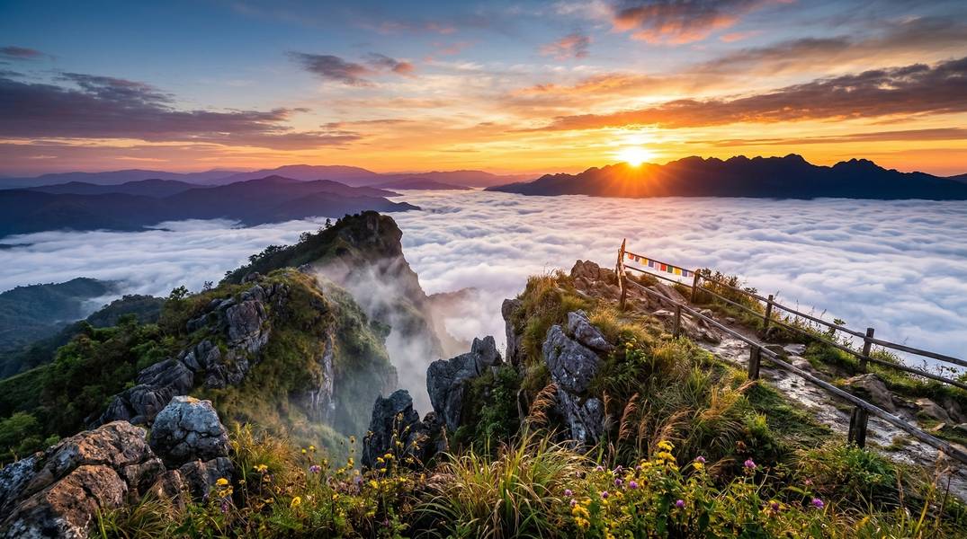
ภูชี้ฟ้า • Phu Chi Fa — “The Mountain That Points to the Sky”
Rising to 1,628 meters at the northeastern edge of the Phi Pan Nam Range, Phu Chi Fa is a dramatic mountain peak on the Thai-Laos border in Chiang Rai Province. Its name comes from the distinctive pointed rock formation at the summit that appears to point skyward — ภู (Phu) meaning mountain, ชี้ (Chi) meaning to point, and ฟ้า (Fa) meaning sky.
Designated as a Forest Park in 1998 (not a full National Park — which accounts for its lower entry fees), Phu Chi Fa draws 250,000-300,000 visitors annually for one signature experience: watching sunrise paint a sea of mist gold and pink from the cliff edge, with the Mekong River valley and Laos stretching to the horizon below. During December and January, Wild Himalayan cherry blossoms (Prunus cerasoides) line the roads connecting Phu Chi Fa to nearby Doi Pha Tang.
For medical tourists, Phu Chi Fa is a rewarding but demanding destination. The short trail (750m) is manageable for reasonably fit individuals, but the very early wake-up, cold temperatures, remote location, and lack of nearby medical facilities mean this is best suited for patients who are fully recovered and seeking a unique Thai experience — not those in active post-operative recovery.
Important: Park fees, hours, trail conditions, and road conditions are subject to change. Verify current information before your visit. Weather conditions, mist formations, and sunrise views cannot be guaranteed. Check current border security conditions before planning a trip — Phu Chi Fa overlooks the Laos border.
Why Phu Chi Fa is Special
The Sea of Mist
Phu Chi Fa’s signature attraction is the sunrise sea of mist — a natural phenomenon where morning clouds settle in the valleys below the summit, creating the appearance of an ocean of white and gold stretching toward Laos. The cliff-edge viewpoint faces east over the Mekong River valley and Bokeo Province, Laos, providing an unobstructed panorama.
What makes this viewpoint exceptional:
- Cliff-edge position: The distinctive pointed rock outcrop juts eastward, placing viewers directly above the mist
- Cross-border panorama: Views extend across the Mekong valley into Laos
- Golden grasslands: The summit’s ~300 rai (~48 hectares) of montane grassland turns golden in winter, framing the mist
- Cherry blossom corridor: December-January brings Prunus cerasoides blooms along roads to and from the summit
Forest Park Classification
Phu Chi Fa is classified as a Forest Park (อุทยานแห่งชาติป่าไม้), not a full National Park under the Department of National Parks (DNP). Some sources incorrectly refer to it as “Phu Chi Fa National Park.” This distinction matters for visitors:
- Lower entry fees: 20 THB vs. 200-400 THB for DNP national parks
- Less infrastructure: Fewer facilities than full national parks
- Community-managed: Stronger connection to local Hmong and Yao hill tribe communities
Cultural Significance
The Phu Chi Fa area is home to Hmong and Yao (Mien) hill tribe communities who have lived in these mountains for generations. Nearby Doi Pha Tang area also includes Chinese Haw villages. Community-based tourism is the economic backbone here — informal food stalls, handicraft vendors, and small family guesthouses rather than resort-style development.
Natural Features & Ecology
Landscape and Geography
Phu Chi Fa sits at the northeastern end of the Phi Pan Nam Range (Doi Pha Mon sub-range), where the mountains slope toward the Mekong River and Laos. The summit features approximately 300 rai of montane grassland surrounded by tropical and subtropical rainforest on the slopes below.
| Feature | Details |
|---|---|
| Summit elevation | 1,628m (some sources cite 1,625m for the specific viewpoint cliff) |
| Elevation range | 1,200m - 1,628m |
| Climate zone | Tropical highland / montane |
| Grassland area | ~300 rai (~48 hectares) at summit |
| Protected area | Forest Park since February 6, 1998 |
| Province | Chiang Rai |
| Border | Overlooks Bokeo Province, Laos and the Mekong River valley |
Flora Highlights
The park supports a mix of tropical rainforest on slopes and montane grassland at summit elevations.
Notable Trees and Plants:
- White orchid tree (Bauhinia variegata)
- Sweet chestnut (Castanea sativa)
- Mountain beech (Fagus hayatae)
- Cinnamon (Cinnamomum verum)
- Wild champak (Magnolia champaca)
- Magnolia sirindhorniae (sarapee)
Wild Himalayan Cherry (Thai Sakura): Prunus cerasoides blooms December through January along the highway connecting Phu Chi Fa and Doi Pha Tang, forming a corridor of pink blossoms. Cultivated specimens also grow at Banpot Wittaya School near Doi Pha Tang.
Grasslands:
- Golden-hued montane grassland in winter and summer
- Lush green during rainy season
- Cogon grass (Imperata cylindrica), broom grass (Thysanolaena maxima), and vetiver grass (Chrysopogon zizanioides)
- Ground orchids and various fern species
Fauna
Wildlife at Phu Chi Fa is present but rarely encountered on the main tourist trail. The surrounding forest supports diverse species.
| Animal | Likelihood on Main Trail |
|---|---|
| Deer and barking deer | Low (forest dwellers) |
| Wild boar | Low |
| Civet | Rare (nocturnal) |
| Wild cats | Rare |
| Flying squirrels | Occasional (dawn/dusk) |
| Mongoose | Rare |
| Wild hares | Occasional |
Note: Wildlife sightings are never guaranteed. Animals are wild and free-roaming across the forest. Maintain distance and do not feed wildlife.
Notable Birds:
- Greater coucal (Centropus spp.)
- White-rumped shama (Copsychus malabaricus)
- Red-whiskered bulbul (Pycnonotus blanfordi)
- Red junglefowl (Gallus gallus)
- White-crested laughingthrush (Garrulax leucolophus)
- Various hawks, barn owls, starlings, magpies, orioles, mynas, drongos, and warblers
Activities & Experiences
Sunrise Viewing
The signature activity at Phu Chi Fa. Watching sunrise from the cliff-edge viewpoint as the sea of mist fills the valleys below is one of Thailand’s most atmospheric natural experiences.
| Detail | Information |
|---|---|
| Best position | Summit cliff viewpoint facing east toward Laos |
| Timing | Arrive parking by 05:45 AM; sunrise ~06:30 AM (cool season) |
| Duration | Allow 40 minutes before sunrise; most visitors leave within 1 hour after |
| Crowds | Very crowded on December-January weekends |
| Tip | Visit weekdays for a quieter experience |
Post-Surgery Suitability: Moderate — requires 750m uphill pre-dawn hike in cold conditions. Suitable from Week 3+ for minor procedures; not recommended during active recovery from major surgery.
Hiking Trails
| Trail | Distance | Elevation Gain | Time | Difficulty |
|---|---|---|---|---|
| Phu Chi Fa Viewpoint (main) | 750m one way | ~120m | 20-30 min up | Moderate |
| Viewpoint Loop West | 1.6 km | 122m | 30-60 min | Moderate |
| Viewpoint North Route | 1.1 km | 90m | 30-60 min | Moderate (rugged) |
| Viewpoint Extended Route | 3.7 km | 214m | 1.5-2 hours | Moderate |
Main Trail Details:
- Surface: Dirt path, rocky sections, can be muddy and slippery
- Shade: Partial — forested lower section, fully exposed at summit
- Permits: Not required
- Guide: Not required
- Conditions: Very dark pre-dawn; slippery with morning dew or after rain
Stargazing
The remote mountain location with minimal light pollution offers good stargazing potential on clear nights.
| Detail | Information |
|---|---|
| Best conditions | New moon nights during cool/dry season (November-February) |
| Designation | No formal dark sky designation |
| Limitation | Cloud and mist may limit visibility |
Photography
Phu Chi Fa is a photographer’s destination. Professional photographers recommend spending multiple nights (3+ dawns) to maximize chances of ideal mist conditions.
Best Subjects:
- Sea of mist at sunrise
- Cliff-edge silhouettes against dawn sky
- Cherry blossoms (December-January)
- Golden grasslands
- Mekong valley panorama
- Hill tribe portraits (with permission)
Tips:
- Mist conditions vary daily — patience and multiple visits yield the best results
- Doi Pha Tang (12 km) is better for sunset photography
- Burning season (March-May) creates severe haze that ruins visibility
Cultural Experiences
Visit Hmong and Yao hill tribe villages near the park for an authentic cultural dimension.
- Browse handmade crafts and textiles
- Sample local food at stalls and markets (seasonal)
- Traditional dress photography (always ask permission)
- Community-based informal tourism
Respect Hmong and Yao cultural customs. Ask permission before photographing villagers. Support local vendors by purchasing directly from community stalls.
Camping
| Detail | Information |
|---|---|
| Available | Yes — 2 campsites (one inside gate, one outside) |
| Own tent | ~50 THB |
| Tent rental (3-person) | ~150-225 THB |
| Full package (tent + sleeping bag + mat + pillow) | ~300 THB |
| Flashlight rental | 10 THB |
| Booking | Walk-in only for forest park campsites; private camps bookable online |
| Inside-gate note | Must arrive before 6 PM gate closure |
| Food | No restaurants at campsites — buy dinner before arriving |
Prices subject to change. Camping fees may vary between the two campsites and by season. Payment is cash only — no ATMs in the area. Verify current rates on arrival.
Trail Guide
Main Trail: Parking to Summit Viewpoint
The primary trail that most visitors use for the sunrise experience.
| Segment | Details |
|---|---|
| Total distance | ~750m one way |
| Elevation gain | ~120m |
| Time | 20-30 minutes up, 15-20 minutes down |
| Surface | Dirt path, rocky sections, some stairs |
| Shade | Partial cover in forested lower section; exposed at summit |
| Rest points | Limited — a few flat spots along the trail |
| Difficulty | Moderate (uphill, uneven terrain, dark pre-dawn) |
| Facilities | None along trail; restrooms at parking area |
Trail Notes:
- The first section passes through forest — moderate shade, uneven footing
- A 400m section from the first viewpoint to the summit can be very dark pre-dawn — bring a headlamp or flashlight
- Rocky and potentially slippery throughout, especially with morning dew
- The summit viewpoint is an exposed cliff edge with no safety barriers
Extended Routes
The Viewpoint Loop West (1.6 km) and Extended Route (3.7 km) offer additional exploration beyond the main viewpoint for those with more time and fitness.
These extended routes are not recommended for recovering medical tourists due to longer distances, rugged terrain, and remoteness from any assistance.
For Medical Tourists
Physical Requirements Assessment
| Factor | Level | Details |
|---|---|---|
| Walking Distance | 750m-1.6 km one way | Main trail is 750m; extended options available |
| Elevation | 1,200-1,628m | Below altitude symptom threshold for most visitors |
| Temperature | 5-25°C | Very cold pre-dawn (5-10°C); warms after sunrise |
| Trail Surface | Unpaved | Dirt, rocks, stairs — slippery when wet |
| Shade | Partial | Forested lower trail; exposed summit |
| Rest Areas | Limited | Few flat spots on trail; ample rest at summit |
| Mobile Signal | Unreliable | Patchy coverage; AIS has best signal in region |
| Medical Facilities | Remote | 50+ km to nearest district hospital |
Post-Surgery Suitability
| Activity | Suitability | Key Considerations |
|---|---|---|
| Summit sunrise hike | ⚠️ Moderate caution | 750m uphill, cold, dark, slippery, remote |
| Camping at base | ⚠️ Moderate caution | Cold overnight, basic facilities, no medical access |
| Cherry blossom driving | ✅ Suitable Week 2+ | Vehicle-based; minimal walking |
| Village visits | ✅ Suitable Week 2+ | Gentle walking, cultural experience |
| Extended trails (1.6-3.7 km) | ❌ Not recommended | Rugged terrain, remote, strenuous |
Procedure-Specific Guidance
| Procedure Type | Earliest Visit | Recommended Activities |
|---|---|---|
| Dental (simple) | Week 2-3 | Sunrise hike if comfortable; cherry blossom drive |
| Minor cosmetic | Week 2-3 | Sunrise hike with caution; cold may affect healing |
| Dental implant | Week 3 | Sunrise hike if fit; village visits |
| LASIK | Week 2 | All activities; bring sunglasses for altitude glare |
| Rhinoplasty | Week 3 | Cold mountain air may cause discomfort — face covering recommended |
| Abdominal surgery | Week 3-4 | Doctor approval required — uphill trail stresses core |
| Orthopedic (minor) | Week 3-4 | Doctor approval required — uneven terrain, fall risk |
| Cardiac procedures | ❌ | Not recommended — cold exposure, physical exertion, remote location |
| Hip/knee replacement | ❌ | Not recommended — uneven trail, stairs, slippery conditions |
| Major surgery | ❌ | Not recommended — remote, no medical facilities, cold, physical trail |
Medical Advisory: Phu Chi Fa is one of the most remote nature destinations in this collection. The nearest district hospital is approximately 50 km away (Thoeng Hospital, ~1 hour by car), and the nearest full-service hospital is in Chiang Rai city (~100 km, ~2 hours by car). Cold pre-dawn temperatures, unreliable mobile signal, and the cliff-edge viewpoint with no barriers require serious consideration for anyone in post-operative recovery. Consult your treating physician before visiting.
Key Medical Tourist Concerns
- Remote location: 50+ km from nearest hospital, 100 km from regional hospital
- Cold exposure: Pre-dawn temperatures of 5-10°C may affect surgical wounds or cardiac patients
- No mobile signal: Unreliable coverage for emergency calls at summit
- Trail slipperiness: Morning dew and uneven terrain increase fall risk
- Very early wake-up: 4-5 AM departure may affect recovery rest
- No medical facilities: No first aid stations on site; no rangers on trail
- Cliff edge: Unprotected viewpoint — significant fall risk for anyone unsteady
Nearest Hospitals
| Hospital | Type | Distance | Travel Time |
|---|---|---|---|
| Thoeng Hospital | District (basic) | ~50 km | ~1 hour |
| Chiang Rai Prachanukroh Hospital | Regional (773 beds, full emergency, 24hr ambulance) | ~100 km | ~2 hours |
| Overbrook Hospital Chiang Rai | Private | ~100 km | ~2 hours |
Emergency Contacts:
- Medical Emergency: 1669
- Tourist Police: 1155
- Police: 191
- Fire: 199
Getting There
From Bangkok
| Step | Option | Duration | Cost |
|---|---|---|---|
| Flight | Bangkok → Chiang Rai (Mae Fah Luang Airport, CEI) | ~1.5 hours | 1,500-4,000 THB |
| Ground | Chiang Rai → Phu Chi Fa | 2-2.5 hours | Private car or rental |
| Total | Door to door | ~4-5 hours | Variable |
From Chiang Rai by Car (Recommended)
| Detail | Information |
|---|---|
| Distance | 108 km |
| Duration | 2-2.5 hours |
| Route | Route 1 south → Road 1020 east → Road 1021 → Route 1155 → follow signs |
| Road condition | Sealed tarmac entire way; last 30 minutes is winding mountain road with some potholes |
| Fuel | Fill up in Chiang Rai — no gas stations open at 3 AM departure time |
Public Transport (Limited)
Getting to Phu Chi Fa by public transport is possible but challenging.
Step 1: Chiang Rai to Thoeng
| Detail | Information |
|---|---|
| Transport | Bus from Chiang Rai bus station |
| Duration | ~90 minutes |
| Frequency | Every 30 minutes |
Step 2: Thoeng to Phu Chi Fa
| Option | Details | Cost |
|---|---|---|
| Shared songthaew | From behind Thoeng fresh market, departs ~2 PM | ~150 THB per person |
| Private songthaew | Negotiated hire | ~800 THB |
Seasonal Minivan (November-February only): An unofficial direct minivan service runs Chiang Rai → Phu Chi Fa during peak season. Departs Bus Station 1, platform #3 at 1:30 PM (~10 seats, ~3 hours). Return 9 AM. Book early — this service operates without formal schedule and may change without notice.
Alternative Transport
| Option | Cost | Notes |
|---|---|---|
| Private taxi from Chiang Rai | 1,500-2,000 THB | Most convenient (~$40-50 USD) |
| Tour package (up to 3 people) | ~3,000 THB per car | Includes transport and waiting |
| Motorbike rental from Chiang Rai | 200-300 THB/day | Experienced riders only — winding mountain road |
Driving Tips
- Fuel up the night before if departing for sunrise — no gas stations open at 3 AM
- Last stretch is winding mountain road — drive carefully, especially in darkness
- Download offline maps — mobile signal is unreliable en route
- Motorbike caution: Thailand has a high motorbike accident rate; experienced riders only on mountain roads
Accommodation
Inside the Park
Camping (walk-in only):
| Detail | Cost |
|---|---|
| Own tent | ~50 THB |
| 3-person tent rental | ~150-225 THB |
| Full camping package | ~300 THB |
| Sleeping bag rental | ~50 THB |
Two campsites available — one inside the gate (must arrive before 6 PM) and one outside (similar facilities).
Nearby Village Options
Budget (200-800 THB):
- Village bungalows and guesthouses — basic, often not bookable online (walk-in)
- Phu Chi Fa Dok Sieo: Cabins outside park gate with 4:30 AM transport to trailhead
Mid-Range (800-1,500 THB):
- Phumork Camp Phu Chi Fa — mountain views, balcony
- Baan Rabiengfah Resort
- Phucheefah Yodmanee Resort
Glamping (1,500+ THB):
- Long Hug Khao Camping Phu Chi Fa — plexiglass dome tents on mountain slope
- Phuchifa Sky Camp — valley views, sky domes
- Chillchillcamp Phuchifa — terrace, balcony, breakfast included
Booking Tips
- Many village lodgings are not bookable online — arrive and ask (avoid Thai holidays and weekends)
- During peak weekends (December-January), accommodation can sell out entirely
- Online-bookable options available via Agoda, Booking.com, and Trip.com
- No restaurants at campsites — buy dinner at small village eateries on the road up before reaching the park
- Bring snacks and water for the sunrise hike
Food
Small village eateries and seasonal stalls line the road up to the park. There are no restaurants at the campsites or summit. Buy dinner before reaching the park and bring snacks and water for the early morning.
Practical Tips
What to Pack
Essential:
- Heavy jacket, gloves, scarf, hat — pre-dawn temperatures 5-10°C
- Layers — cold at summit, warms rapidly after sunrise
- Sturdy hiking shoes with good grip — NOT sandals or flip-flops
- Headlamp or flashlight — essential for dark pre-dawn trail (or rent at park for 10 THB)
- Walking stick or poles — helpful for descent, especially if muddy
- Cash (THB) — no ATMs in the area; cash only for all services
- Water and snacks — nothing available at summit
- Offline maps — download before departure (no reliable signal)
- Sunscreen and sunglasses — strong sun at altitude after sunrise
What NOT to Bring
- Single-use plastics — respect leave-no-trace principles
- Expectations of guarantees — weather and mist conditions vary daily
Trail Safety
- Wear proper hiking shoes with good grip — the trail is rocky and can be very slippery
- Bring a headlamp — the pre-dawn ascent is dark and the path is uneven
- Use walking sticks for the descent, especially if conditions are muddy
- Exercise extreme caution at the cliff-edge viewpoint — there are no barriers
- Stay on the marked trail to protect summit grassland ecology
Cold Weather Preparation
Pre-dawn temperatures of 5-10°C (record: 1°C) require proper clothing:
- Heavy jacket or down coat
- Fleece or thermal underlayer
- Gloves (fingers get cold while waiting for sunrise)
- Warm hat or beanie
- Scarf or neck gaiter
- Warm socks
- Blankets may be needed for camping (some camps provide them)
Wildlife and Insect Safety
Wildlife risk on the main trail is low — no significant dangerous species reported. Keep food secured at campsites to avoid attracting wild animals.
Environmental Responsibility
Leave No Trace
Phu Chi Fa’s summit grasslands are a fragile ecosystem:
- Pack out all rubbish — dispose properly; do not litter on trails or at the viewpoint
- Stay on marked trails — protect the montane grassland ecology from erosion
- No campfires outside designated areas
- Do not pick plants or wildflowers — they belong to the ecosystem
Ethical Wildlife Interaction
- Do not feed wildlife
- Maintain distance from wild animals
- Do not use flash photography on wildlife
Community Respect
Phu Chi Fa is surrounded by Hmong and Yao hill tribe communities:
- Ask permission before photographing hill tribe villagers
- Support local vendors and community-run accommodation
- Respect cultural customs — these are living communities, not tourist attractions
- Guide fees and purchases go directly to local families
Burning Season Warning
March through May is burning/smoke season — farmers clear fields through agricultural burning. This causes:
- Severe haze affecting all visibility
- Poor air quality dangerous for respiratory patients
- Completely ruined photography and sunrise conditions
Do not visit Phu Chi Fa during March-May. The experience is fundamentally compromised.
Seasonal Guide
Month-by-Month Conditions
| Month | Conditions | Temperature (Summit) | Medical Tourist Rating |
|---|---|---|---|
| January | Peak season, best mist, cherry blossoms. Very crowded weekends. | 5-10°C dawn, 20-25°C day | Excellent |
| February | Excellent conditions, good mist. Warming slightly. Cherry blossoms fading. | 8-15°C dawn, 22-27°C day | Excellent |
| March | Burning season begins. Haze and smoke. Mist unreliable. | 10-20°C | Not recommended |
| April | Peak burning season. Severe haze. Hot. Most accommodation closed. | 15-35°C | Not recommended |
| May | Transition to rain. Smoke clearing but rain starting. | 15-28°C | Not recommended |
| June | Rainy season. Heavy rain, slippery trails, limited visibility. | 15-25°C | Not recommended |
| July | Rainy season continues. Lush green hills but muddy trails. | 15-25°C | Not recommended |
| August | Heavy monsoon. Trails dangerous. | 15-25°C | Not recommended |
| September | Peak monsoon. Heaviest rainfall. | 15-25°C | Not recommended |
| October | Rain easing. Landscape transitioning to golden hue. | 12-22°C | Fair (late month) |
| November | Cool season begins. Mist starts forming. Accommodation reopens. | 8-18°C | Good |
| December | Peak season, excellent mist. Cold mornings. Cherry blossoms starting. | 5-12°C dawn, 20-25°C day | Excellent |
Best Months for Activities
| Activity | Best Months | Notes |
|---|---|---|
| Sea of mist sunrise | December - January | Peak mist conditions |
| Cherry blossoms (Thai Sakura) | December - January | Along road to Doi Pha Tang |
| Photography | November - February | Clear conditions, golden grasslands |
| Stargazing | November - February | Clear skies, low humidity |
| Camping | November - February | Comfortable conditions (cold nights) |
| Cultural village visits | November - February | Seasonal markets and stalls active |
When NOT to Visit
- March-May: Burning season — severe haze, poor air quality, accommodation closed
- June-October: Monsoon — heavy rain, slippery trails, poor visibility, unreliable mist
Nearby Attractions
Nature
| Attraction | Distance | Highlight |
|---|---|---|
| Doi Pha Tang | 12 km (25 km by road) | 3 viewpoints. Said to be equally stunning — especially for sunset. 1,900m elevation. |
| Phu Sang National Park & Hot Spring Waterfall | ~35 km | Warm waterfall from hot springs (35°C), caves, natural warm bathing pond |
| Phu Chi Dao | Nearby (same sub-range) | Alternative mountain viewpoint |
| Phu Chi Duen | Nearby | 1,742m peak accessible by foot or 4WD |
| Cherry Blossom Road | Between Phu Chi Fa and Doi Pha Tang | Prunus cerasoides corridor, December-January bloom |
Therapeutic Link for Medical Tourists
Phu Sang Hot Springs (~35 km from Phu Chi Fa) features natural warm water from hot springs at 35°C. The mineral-rich water may provide comfort for muscle relaxation — a worthwhile addition to a multi-day trip. Caves include Tham Pha Dan, Tham Nam Lot, and Tham Nam Daeng.
Hot spring immersion requires doctor approval for patients with recent surgical wounds.
Cultural
- Hmong and Yao hill tribe villages surrounding the park
- Chinese Haw villages near Doi Pha Tang
- Golden Triangle (Chiang Saen / Chiang Khong) — historical significance
Markets
- Thoeng fresh market (also the songthaew departure point)
- Seasonal hill tribe stalls near park entrance (November-February)
Nearby Destinations to Combine
For visitors spending multiple days in the Chiang Rai highlands:
Day 1: Arrive Chiang Rai, evening drive to Phu Chi Fa area Day 2: Sunrise at Phu Chi Fa → Cherry Blossom Road → Doi Pha Tang (sunset) Day 3: Phu Sang Hot Springs → Return to Chiang Rai
This itinerary combines the dramatic sunrise experience with cherry blossoms, sunset viewpoints, and therapeutic hot springs — a well-rounded nature experience for recovered patients.
Border Security Note
Phu Chi Fa overlooks the Laos border (Bokeo Province). In May 2025, the viewpoint was temporarily closed following armed clashes in Pak Tha, Bokeo Province, with stray bullets crossing into Thai territory. This was an isolated event, but the proximity to the international border means visitors should:
- Check current conditions before planning a visit
- Contact TAT Chiang Rai or local authorities for latest border security status
- Monitor Thai news for any advisories regarding the Chiang Rai border area
Safety Summary
- Trail: Short (750m) but uphill, rocky, dark pre-dawn, and potentially slippery
- Cliff: Summit viewpoint has no safety barriers — exercise extreme caution
- Cold: Pre-dawn temperatures 5-10°C (record 1°C) — dress warmly
- Remote: 50+ km to nearest hospital; 100 km to full-service hospital
- Signal: Mobile coverage unreliable — do not rely on phone for emergencies
- Driving: Winding mountain road; fuel up in advance; experienced riders only for motorbikes
- No facilities: No first aid stations, no rangers on trail, no ATMs, limited shops
Disclaimer: Outdoor activities involve inherent risks. Weather conditions, trail conditions, mist formations, and border security situations are unpredictable and cannot be guaranteed. Park fees, hours, and regulations may change without notice. Medical tourists should consult their treating physician before visiting — cold temperatures, remote location, and physical trail demands require consideration for all post-surgical patients. This content is informational only and does not constitute medical advice.
Useful Thai Phrases
| English | Thai | Pronunciation |
|---|---|---|
| Hello | สวัสดี | Sa-wat-dee |
| Thank you | ขอบคุณ | Khob khun |
| How much? | เท่าไหร่? | Thao rai? |
| Mountain | ภูเขา | Phu khao |
| Summit / Peak | ยอดดอย | Yot doi |
| Cold | หนาว | Nao |
| Sunrise | พระอาทิตย์ขึ้น | Phra a-thit kheun |
| Mist / Fog | หมอก | Mork |
| Help! | ช่วยด้วย! | Chuay duay! |
| Where is…? | …อยู่ที่ไหน? | …yoo tee nai? |
Frequently Asked Questions
Is Phu Chi Fa safe to visit after surgery?
This destination is best suited for patients who are fully recovered rather than in active recovery. The 750m uphill trail, very early wake-up (4-5 AM), cold pre-dawn temperatures (5-10°C), and remote location (50+ km from nearest hospital) make it challenging for recovering patients. If you have had minor dental or cosmetic procedures and are at least 2-3 weeks post-surgery, discuss with your doctor. For cardiac, orthopedic, or major surgical patients, this is not recommended during recovery. Consult your treating physician before visiting.
How physically demanding is the hike?
The main trail is approximately 750 meters one way from the parking area to the summit viewpoint, taking 20-30 minutes uphill. The trail is moderately difficult — unpaved with rocky sections, some stairs, and uneven terrain that can be muddy and slippery. The total effort is short but continuous uphill walking. Pre-dawn conditions add difficulty due to darkness (headlamp required) and cold temperatures.
Is there mobile phone signal for emergencies?
Mobile signal is patchy and unreliable on the mountain. AIS offers the best coverage in the region, but signal drops frequently. Do not rely on your phone for navigation or emergency calls at the summit. Download offline maps before departing and inform someone of your itinerary. Most guesthouses have basic Wi-Fi (slow).
Can I visit during rainy season?
Not recommended. June through October brings heavy rain, slippery trails, limited visibility, and unreliable mist conditions. March through May is also not recommended due to agricultural burning that causes severe haze. The destination is essentially only worthwhile November through February.
Are guides required for the hike?
No guides are required. The trail to the summit viewpoint is straightforward and well-trodden during peak season. However, you should bring a headlamp or flashlight for the pre-dawn ascent — a section of the trail can be dark. Flashlights are available to rent at the park for 10 THB.
What is the best time to see the sea of mist?
The sea of mist is most spectacular during the cool season, December through January. Arrive at the parking area by 05:45 AM and begin hiking immediately for the approximately 06:30 AM sunrise. Conditions vary daily — mist formation depends on temperature, humidity, and overnight weather. Spending multiple mornings increases your chances of ideal conditions.
How cold does it get?
Pre-dawn temperatures at the summit range from 5-10°C during cool season, with the record low at 1°C in January. It warms rapidly after sunrise to 20-25°C. Bring a heavy jacket, gloves, scarf, and hat for the pre-dawn hike. Layers are essential as you will want to shed them as the sun rises.
Is there accommodation near Phu Chi Fa?
Yes, ranging from basic village guesthouses (200-800 THB) to glamping camps (1,500+ THB). Many village options are not bookable online — walk-in only. During peak weekends in December-January, accommodation can fill up. The park also offers camping (50 THB for own tent, ~300 THB for full package). There are no restaurants at the campsites — buy dinner before arriving.
Need Help Planning Your Visit?
Our team can help coordinate your visit to Phu Chi Fa during your stay in Thailand.
Check your insurance coverage before booking your medical trip.