Thi Lo Su Waterfall
Overview
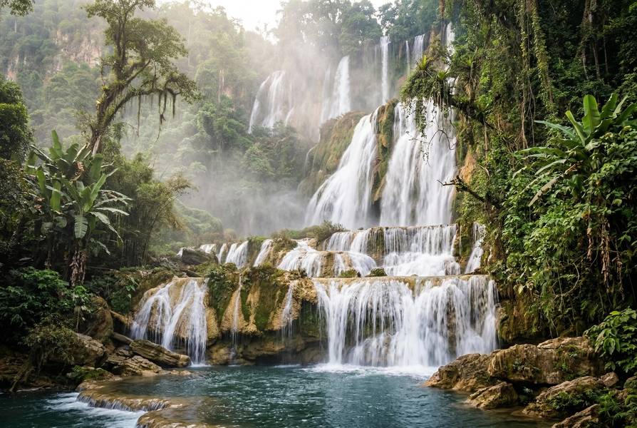
น้ำตกทีลอซู • Thi Lo Su Waterfall (Namtok Thi Lo Su)
Hidden deep within the Umphang Wildlife Sanctuary near the Myanmar border, Thi Lo Su is Thailand’s largest waterfall — a multi-tiered limestone cascade approximately 250 meters high and 450 meters wide, plunging through pristine jungle in one of Southeast Asia’s last great wilderness areas. The name comes from the S’gaw Karen language (ထံလီၤဆူ), meaning “Black Waterfall.”
The Umphang Wildlife Sanctuary, established in 1989, covers 2,590 sq km within the Western Forest Complex — a vast network of 19 protected areas spanning 18,730 sq km across Thailand and Myanmar. This complex is a UNESCO World Heritage candidate and one of only two territories in Thailand where wild tigers persist.
This is an adventure destination for fully healthy, physically fit visitors. The remoteness, multi-day journey, camping-only accommodation, and lack of medical facilities make Thi Lo Su one of Thailand’s most challenging — and most rewarding — nature experiences. It is not suitable for medical tourists recovering from any procedure.
Important: Park fees, road access policies, and conditions change frequently. Verify all information with local tour operators before traveling. Wildlife sightings and weather conditions cannot be guaranteed. The waterfall has never been formally surveyed — all dimensions are approximate.
Why Thi Lo Su is Special
Thailand’s Largest Waterfall
Thi Lo Su is claimed as Thailand’s largest waterfall by volume, ranked 6th largest in Asia by some sources. The multi-tiered limestone cascade stretches approximately 250 meters in height and 450 meters in width, creating a wall of white water visible from the campsite trail during peak flow months (November-January).
Note: These dimensions have never been formally surveyed. Various sources cite heights of 200-300 meters and widths of 400-500 meters.
Western Forest Complex Significance
The Umphang Wildlife Sanctuary is a critical piece of the Western Forest Complex, which protects:
- 18,730 sq km of contiguous forest across Thailand and Myanmar
- 120+ mammal species, 400+ birds, 96 reptiles, 43 amphibians
- 34 internationally threatened species
- One of only two tiger populations in Thailand (175-223 individuals nationally)
- Adjacent to UNESCO-inscribed Thung Yai Naresuan and Huai Kha Khaeng Wildlife Sanctuaries
Conservation Achievements
- Global Conservation / WCS Thailand partnership protecting 120,000+ hectares
- SMART Patrol System operational since 2010
- 15 ranger stations with approximately 70 patrol rangers across the sanctuary
- Thailand’s tiger population has achieved the first increase in Southeast Asia
Natural Features & Ecology
Landscape
The waterfall sits in a steep river valley within the Thanon Thongchai mountain range, fed by the Mae Klong River (Huai Klotho stream). The sanctuary spans elevations from 80 meters to 2,152 meters, creating diverse ecological zones.
Flora
The sanctuary protects three primary forest types:
| Forest Type | Area | Elevation |
|---|---|---|
| Tropical dry evergreen forest | ~148,200 ha | Above 1,000 m |
| Deciduous forest | ~87,500 ha | Lower elevations |
| Tropical moist evergreen forest | Pockets | Southern areas |
Notable plant species include teak (Tectona grandis) along the Mae Klong riverbanks, ironwood (Hopea spp.), dipterocarp species, giant bamboo, strangler figs, orchids, ferns, and over 1,300 palm varieties.
Fauna
The Umphang Wildlife Sanctuary hosts an extraordinary diversity of wildlife. Sightings depend on season, time of day, location, and luck — animals roam freely across 2,590 sq km.
Mammals:
| Species | Conservation Status | Notes |
|---|---|---|
| Asian Elephant (Elephas maximus) | Endangered | Present but elusive |
| Indochinese Tiger (Panthera tigris corbetti) | Endangered | One of only two Thai populations |
| Indochinese Leopard | Vulnerable | Rarely seen |
| Clouded Leopard | Vulnerable | Nocturnal, rare |
| Sun Bear | Vulnerable | Secretive |
| Asiatic Black Bear (Ursus thibetanus) | Vulnerable | Present in forested areas |
| Malayan Tapir | Endangered | Nocturnal |
| Gaur (Bos frontalis) | Vulnerable | Asia’s largest bovine |
| White-handed Gibbon | Endangered | Commonly heard singing at dawn |
| Mainland Serow | Near Threatened | Rocky terrain |
Reptiles: Elongated Tortoise (EN), Asian Giant Tortoise (EN), Impressed Tortoise (VU), Indo-Chinese Spitting Cobra, and various other snake species.
Birdwatching
With 177+ species recorded (106 eBird checklists), the sanctuary is a BirdLife International Important Bird Area (IBA).
Key Species:
- Burmese Yuhina (Yuhina humilis) — restricted-range species and key draw for birders
- Long-tailed Sibia
- Black-throated Parrotbill
- Wreathed Hornbill and Great Hornbill
- Green-tailed Sunbird
- Rusty-capped Fulvetta
- Chestnut-tailed Minla
- Yellow-bellied Fantail
Best Birding: The road through the sanctuary provides the most accessible birding. Doi Kejala summit offers montane species but requires ranger permission and a guide. Early morning (05:30-07:00) and dusk (16:30-18:00) are optimal.
Geological Features
- Multi-tiered limestone cliff formations at the waterfall
- Ta Ko Bi Cave (stalactites and stalagmites, formerly used by Communist Party of Thailand)
- Doi Hua Mot viewpoint — a table mountain rising above the clouds
- Natural hot springs along the rafting route
Water Features
| Feature | Description |
|---|---|
| Thi Lo Su Waterfall | Main attraction — 250 m high, 450 m wide cascade |
| Thi Lo Jo Waterfall | Two-tiered waterfall seen on the rafting route |
| Rainbow Falls | Along the Mae Klong River rafting route |
| Kho Tha (Kota) Waterfall | Near Karen village, 2.5-3 km trek |
| Pi Tu Kro Waterfall | Heart-shaped, claimed highest in Thailand (deep in sanctuary) |
| Natural hot springs | Along the rafting route |
Activities & Experiences
Campsite to Waterfall Trail
The main attraction walk — and the only “easy” part of this adventure.
| Detail | Information |
|---|---|
| Distance | 1.5 km one way (3 km round trip) |
| Difficulty | Easy |
| Elevation Gain | Minimal (~65 m) |
| Surface | Concrete/paved path through jungle |
| Shade | Full jungle canopy |
| Time | 15-30 minutes one way |
| Post-Surgery Suitability | Possible for minor procedures at 4+ weeks IF staying at campsite — but the journey TO the campsite is the real challenge |
Waterfall Summit Trail
| Detail | Information |
|---|---|
| Distance | ~2 km one way from waterfall base |
| Difficulty | Moderate to Challenging |
| Elevation | Significant uphill with river crossings |
| Surface | Rock, water, jungle |
| Time | 2 hours round trip |
| Notes | Involves scrambling over small waterfalls. Swimming restricted during wet season |
Multi-Day Trek (Part of Tour Package)
Most visitors experience Thi Lo Su as part of a 3-4 day guided trek:
| Segment | Distance | Difficulty | Time | Notes |
|---|---|---|---|---|
| Campsite to Karen Village | ~9 km | Moderate | 3-4 hours | Mostly flat along river, some steep sections |
| Karen Village to Route 1090 | ~9 km | Challenging | 3-4 hours | 50+ minutes continuous uphill. Very humid. Hard on knees downhill |
| Rainy Season Jungle Route | ~9 km | Strenuous | 3-4 hours | Rough jungle, slopes, mud. Guide mandatory |
Rafting on Mae Klong River
| Detail | Information |
|---|---|
| Type | Inflatable rubber raft from Umphang to campsite |
| Duration | ~3 hours |
| Difficulty | Easy to Moderate (mostly smooth, one small rapids section) |
| Season | Year-round (primary access method in wet season) |
| Highlights | Hot springs, Rainbow Falls, teak-lined riverbanks |
Swimming
Multi-level pools at the waterfall base and upper sections are accessible for swimming during dry season (November-May). Bring swimwear and water shoes. During wet season, swimming is restricted due to strong currents.
Warning: Flash flooding is a serious risk during and after heavy rain. Never swim above the falls. Observe all ranger instructions.
Wildlife Watching
| Detail | Information |
|---|---|
| Best Species | White-handed Gibbon (heard singing), hornbills, kingfishers, butterflies |
| Best Times | Dawn (05:30-07:00), Dusk (16:30-18:00) |
| Reality | Wildlife is wild and elusive. Gibbons commonly heard but rarely seen |
Photography
Best spots for photography:
- Main waterfall viewing area (full cascade) — morning light best (east-facing valley)
- Upper pools and tiers
- Doi Hua Mot viewpoint (sea of mist, early morning)
- Mae Klong River rafting route
- Karen village cultural scenes
Camping
| Detail | Information |
|---|---|
| Available | Yes — tents at Thi Lo Su campground |
| Facilities | Basic — toilets, showers, small shop at ranger station |
| Cost | ~300 THB per person for fan room bungalow near entrance |
| Booking | Through tour operators (recommended) or DNP system |
Other Experiences
- Karen Village Homestay — cultural experience at Kho Tha village (~400 residents, traditional wooden houses, bucket showers)
- Hot Springs Visit — natural hot springs along the rafting route
- Cave Exploration — Ta Ko Bi Cave with stalactites and stalagmites
- Doi Hua Mot — table mountain viewpoint with sea of mist at dawn
For Medical Tourists
Strong Advisory: NOT RECOMMENDED for Recovery
Thi Lo Su Waterfall is not suitable for medical tourists recovering from any procedure. This is one of Thailand’s most challenging nature destinations, requiring:
- 10-14 hours minimum travel from Bangkok (multiple stages)
- Route 1090 — 169 km with 1,219 curves (severe motion sickness risk)
- Rough 4WD dirt track or multi-hour jungle trek to reach the campsite
- No reliable medical facilities within reasonable distance
- Limited to no mobile phone signal for emergency communication
- Camping-only accommodation at the waterfall
Post-Surgery Suitability
| Procedure Type | Suitability | Notes |
|---|---|---|
| Dental (simple) | Not Recommended | Journey alone is unsuitable during recovery |
| Minor cosmetic | Not Recommended | Remote location, rough roads, no medical backup |
| LASIK | Not Recommended | Dust, humidity, no optometrist access |
| Orthopedic | Not Recommended | Challenging terrain incompatible with recovery |
| Cardiac | Absolutely Not | No emergency cardiac care within hours |
| Major surgery | Absolutely Not | Any medical emergency requires hours of transport |
When to Visit
This destination is best experienced before medical treatment or after full recovery (4+ months post-procedure for major procedures). It should be considered a bucket-list adventure for healthy, physically fit visitors who happen to be in Thailand.
Nearest Medical Facilities
| Facility | Distance from Waterfall | Travel Time | Type |
|---|---|---|---|
| Umphang Hospital | ~28-35 km | 1-2 hours via 4WD (dry season) | Small community hospital, limited resources |
| Mae Sot Hospital | ~200 km | 5-7 hours via mountain road | General hospital, better equipped |
| Tak Hospital | ~300 km | 7-9 hours | Provincial hospital |
| Bangkok hospitals | ~450+ km | 10-14 hours or airlift | Full tertiary care |
Umphang Hospital is a small community hospital connected to Mae Sot Hospital via telemedicine. It is not equipped for major emergencies. Helicopter evacuation may be needed for serious incidents.
Emergency Contacts:
- National Emergency: 1669
- Park Ranger Station: On-site at campground
Medical Advisory: This destination requires excellent physical fitness and self-sufficiency. Carry a comprehensive first aid kit, all prescribed medications, and sufficient cash (no ATMs or card facilities at the waterfall). Consult your physician before any outdoor activities post-surgery.
Getting There
Overview: Multi-Stage Journey
The journey from Bangkok to Thi Lo Su involves three stages and takes a minimum of 10-14 hours.
Stage 1: Bangkok to Mae Sot
| Option | Duration | Cost | Notes |
|---|---|---|---|
| Flight (Nok Air / AirAsia) | ~1 hour | Varies | Fastest option to Mae Sot Airport (MAQ) |
| Bus from Mochit Terminal | 8.5-13 hours | ~495 THB | Overnight express available |
| Drive via Tak | 6-7 hours | Fuel costs | 350 km to Tak, then Route 105 to Mae Sot |
Stage 2: Mae Sot to Umphang — Route 1090 (“Death Highway”)
| Detail | Information |
|---|---|
| Distance | 169 km |
| Curves | 1,219 documented curves |
| Duration | 3.5-6.5 hours depending on transport |
| Road Type | Paved, two lanes, constant mountain curves |
Transport Options:
| Option | Duration | Notes |
|---|---|---|
| Songthaew (shared pickup) | 4-6.5 hours | Cheap but long, stops along the way |
| Rental car | ~3.5 hours | Skilled mountain driving required |
| Chartered transport | ~3.5 hours | Arranged via tour operators |
Route 1090 Advice: Despite its name, the “Death Highway” is paved and manageable for experienced mountain drivers. The constant curves through mountains can cause severe motion sickness. Bring motion sickness medication. The road is one of Thailand’s most scenic mountain drives.
Stage 3: Umphang to Thi Lo Su
| Season | Access Method | Duration | Cost |
|---|---|---|---|
| Dry (Nov-May) | Local songthaew/4WD on dirt track (28 km) | 1-2 hours | 2,000-2,500 THB per vehicle |
| Wet (Jun-Oct) | Rubber boat rafting + jungle trek | 6+ hours total | Included in tour packages |
Important: Private vehicle access policies change frequently. At various times, private vehicles have been banned and only local songthaew pickups allowed. Always confirm current policy with tour operators before traveling.
Road Conditions
- Route 1090 (Mae Sot to Umphang): Paved but extremely winding
- Umphang to Thi Lo Su: Dirt/partially paved, heavily eroded, 4WD essential, impassable in wet season
Tour Packages
Recommended Approach
Due to the extreme logistics, booking a tour package is strongly recommended over independent travel.
Standard 3-4 Day Package
| Day | Itinerary |
|---|---|
| Day 1 | Arrive Umphang, accommodation at guesthouse/resort, dinner |
| Day 2 | Rafting on Mae Klong River (3 hrs), hot springs, Rainbow Falls, arrive campsite, afternoon walk to waterfall |
| Day 3 | Optional morning waterfall visit, 9 km jungle trek to Karen village, optional Kho Tha waterfall trek, overnight village homestay |
| Day 4 | 9 km jungle trek back to road, transfer to Umphang |
Pricing
| Package | Price | Notes |
|---|---|---|
| Standard (2+ persons) | 9,500-12,500 THB per person | Includes accommodation, all meals, guide, camping gear, transport |
| Solo traveler | ~12,400 THB | Minimum 2 persons for standard pricing |
Includes: All meals, drinking water, camping equipment, sleeping bags, guides, local transport.
Tour Operators
- Umphang Adventures (umphangadventures.com)
- Various local guesthouses offering packages
- Bangkok-based adventure tour companies
Prices are approximate and subject to change. Confirm pricing directly with operators before booking.
Accommodation
At the Waterfall
| Type | Details | Cost |
|---|---|---|
| Fan room bungalow | Basic rooms near sanctuary entrance | ~300 THB/person |
| Camping | Tents at Thi Lo Su campground | Included in tour packages |
In Umphang Town (28 km from waterfall)
| Category | Examples |
|---|---|
| Budget | Umphang Smile Guesthouse, Umphang Country Hut |
| Mid-range | Umphangburi Resort, Thilosu Riverside, Boonyaporn Resort |
| Riverside | Thee Lor Su Riverside, Umphang Riverside Resort |
Karen Village Homestay
Available at Kho Tha (Kota) Karen Village as part of multi-day tour packages. Traditional wooden houses with bucket showers and a basic snack shop. A genuine cultural experience.
Booking Tip: Book through local tour operators who arrange complete packages. Solo logistics are extremely difficult.
Practical Tips
What to Pack
Essential Items:
- Hiking boots (waterproof, good grip)
- Water shoes or sandals (river crossings and waterfall)
- Long pants and long-sleeved shirt (leech protection)
- Thick socks (leech defense)
- Rain jacket or poncho
- 3+ liters water capacity (water bladder recommended)
- Strong insect/mosquito repellent (DEET-based)
- Sunscreen and hat
- Swimwear
- Flashlight or headlamp
- First aid kit (bandages, antiseptic, antihistamine, salt for leeches)
- Cash in THB (no ATMs or card facilities at the waterfall)
- Plastic bags for waterproofing gear
Recommended:
- Quick-dry clothing (2+ changes)
- Lightweight jacket (cold nights November-February)
- Camera in waterproof bag
- Toiletries and personal hygiene items
- Snacks and energy bars
- Motion sickness medication (for Route 1090)
Weather & Climate
The waterfall area sits at approximately 604 meters elevation in a tropical monsoon zone. Mountainous terrain creates cooler conditions than lowland Thailand.
- November-February: Cool, especially at night (no AC needed). Best conditions overall
- March-May: Hot and very humid. Reduced water flow
- June-October: Heavy monsoon. Road closed. Maximum waterfall volume but access extremely difficult
Leech & Insect Guidance
- Leeches: Prevalent in wet season and near streams. Wear long pants tucked into thick socks. Carry salt. Leech bites cause extended bleeding due to anticoagulant — clean wounds promptly
- Mosquitoes: Bring strong repellent, especially for nighttime at camp
- Snakes: Indo-Chinese Spitting Cobra and other species present. Stay on trails, use flashlight at night, watch where you step
Water Safety
- Strong currents at the waterfall during wet season
- Swimming restricted to designated safe areas
- Flash floods possible during and after heavy rain
- Never swim above the falls
Environmental Responsibility
Wildlife Sanctuary Rules
Umphang Wildlife Sanctuary has higher protection status than national parks. Strict environmental rules apply:
- Do not feed wild animals
- Do not approach elephants or other large wildlife
- Stay on marked trails at all times
- Do not collect plants, animals, rocks, or minerals
- Minimize noise — respect wildlife habitat
- No hunting or trapping
- All waste must be packed out — Leave No Trace
Prohibited Items
- Single-use plastic bags (DNP nationwide ban)
- Styrofoam containers
- Plastic cutlery and straws
- Alcohol (in some periods — check with rangers)
- Loud music or speakers
- Drones (prohibited in wildlife sanctuaries)
Ethical Wildlife Guidelines
The sanctuary’s animals are wild and free-roaming. Wildlife encounters are never guaranteed. Respect their space:
- Maintain safe distance from all animals
- Follow your guide’s instructions at all times
- Use binoculars for closer viewing rather than approaching
- Report injured wildlife to rangers
Community Tourism
The Karen people are the indigenous inhabitants of the Umphang area, predating Thai settlement. The name “Thi Lo Su” (ทีลอซู) comes from the S’gaw Karen language.
Karen village homestays at Kho Tha and Ban Pa La Ta provide community-based tourism income. Local guides and songthaew drivers from the Umphang community are an integral part of the tourism ecosystem.
- Engage respectfully with village communities
- Ask permission before photographing people
- Purchase local handicrafts to support the community
- The Wa Le Community offers Hmong hemp-cloth weaving experiences
Seasonal Guide
Month-by-Month Conditions
| Month | Conditions | Road Access | Water Flow | Rating |
|---|---|---|---|---|
| November | Road opens (~Nov 1). Cool. Full water flow | Open | Peak | Excellent |
| December | Cool weather. Highest water volume. Holiday crowds | Open | Peak | Excellent |
| January | Cool, dry. Strong water flow. Popular period | Open | High | Excellent |
| February | Dry, warming. Water flow begins to decrease | Open | Good | Good |
| March | Hot. Decreasing water flow. Good trekking | Open | Moderate | Moderate |
| April | Very hot. Significantly reduced water flow. Songkran crowds | Open | Low | Moderate-Low |
| May | Early rains. Road conditions deteriorating | Closing | Rising | Transitional |
| June | Road closed (~Jun 1). Spectacular water flow | Closed | High | Closed |
| July | Full monsoon. Maximum volume. Leeches active | Closed | Very high | Closed |
| August | Peak monsoon. Flash flood risk highest | Closed | Maximum | Closed |
| September | Heavy rain. Flash floods. Sanctuary may close entirely | Closed | Very high | Closed |
| October | Monsoon waning. Road still impassable | Closed | High | Closed |
Best Months for Activities
| Activity | Best Months | Notes |
|---|---|---|
| Waterfall viewing | Nov-Jan | Maximum water flow with open road access |
| Hiking | Nov-Feb | Dry trails, comfortable temperatures |
| Swimming | Nov-Mar | Safe water levels, warm days |
| Photography | Nov-Jan | Full cascade, clear mornings, east-facing light |
| Birdwatching | Nov-Apr | Resident species active |
| Rafting | Year-round | Primary access in wet season; tour activity in dry season |
Flowering Seasons
Orchids and wildflowers near waterways bloom year-round, with peak wildflower season in late monsoon (September-November).
Nearby Attractions
Nature Sites
| Attraction | Description |
|---|---|
| Pha Charoen Waterfall & National Park | 97-tier limestone waterfall with 1.5 km nature trail. Rest stop on Route 1090 from Mae Sot |
| Doi Hua Mot | Table mountain viewpoint above the clouds within the Umphang area |
| Thi Lo Jo Waterfall | Two-tiered waterfall seen on the rafting route to Thi Lo Su |
| Kho Tha (Kota) Waterfall | Near Karen village, 2.5-3 km trek |
| Pi Tu Kro Waterfall | Heart-shaped waterfall, claimed highest in Thailand. Deep within sanctuary |
| Ta Ko Bi Cave | Cave with stalactites and stalagmites |
| Huai Nam Nak Hot Spring | Natural hot spring (60 degrees C) with built facilities in Phob Phra District |
Cultural Sites
| Site | Description |
|---|---|
| Kho Tha Karen Village | ~400 residents, 70 homes, primary school. Traditional Karen culture, homestay available |
| Ban Pa La Ta | Karen village dating back 250 years |
| Wa Le Community | Agricultural and cultural attraction with Hmong hemp-cloth weaving |
Hot Springs
Natural hot springs are visited during the rafting portion of tour packages. Huai Nam Nak Hot Spring in nearby Phob Phra District offers a more developed hot spring experience at 60 degrees C.
Dining
Limited options. The campsite has a basic shop. Umphang town has simple restaurants at guesthouses and resorts. All meals are included in tour packages.
Related Destinations in the Western Forest Complex
The Umphang Wildlife Sanctuary is part of a network of connected protected areas:
- Thung Yai Naresuan Wildlife Sanctuary — UNESCO World Heritage Site
- Huai Kha Khaeng Wildlife Sanctuary — UNESCO World Heritage Site
- Khlong Lan National Park
- Mae Wong National Park
- Khlong Wang Chao National Park
- Namtok Pha Charoen National Park — en route, features a 97-tier waterfall
Safety Summary
- Remoteness: Help is far away. The nearest hospital is 1-2 hours by 4WD. Carry a comprehensive first aid kit
- Flash Floods: Serious risk at the waterfall during and after heavy rain. In 2024, flash flooding closed the upper trail and damaged the viewing area
- Wildlife: Wild elephants, venomous snakes (Indo-Chinese Spitting Cobra), and other animals present. Stay on trails, follow your guide
- Leeches: Common in wet season. Wear protective clothing, carry salt
- Heat: Very humid jungle environment. Carry minimum 2-3 liters of water per person for treks
- Roads: Route 1090 is winding and can cause motion sickness. Dirt track to waterfall is rough
- Communication: Very limited to no mobile signal. Inform someone of your plans
- Water Safety: Strong currents during wet season. Never swim above the falls. Flash floods can occur suddenly
Disclaimer: Outdoor activities in remote wilderness areas involve significant inherent risks including flash floods, wildlife encounters, difficult terrain, and limited access to medical care. Weather conditions, trail conditions, and road access are unpredictable and subject to change without notice. This destination is not recommended for medical tourists recovering from procedures. Park fees and access policies may change without notice. Consult your physician before any strenuous outdoor activities. Carry comprehensive travel insurance that covers emergency evacuation.
Frequently Asked Questions
Is Thi Lo Su Waterfall suitable for medical tourists recovering from procedures?
No. Thi Lo Su is NOT recommended for medical tourists recovering from any procedure. The 10-14 hour journey from Bangkok includes a winding mountain road with 1,219 curves (causing motion sickness), a rough 4WD dirt track or multi-hour jungle trek, and camping-only accommodation with no reliable medical facilities nearby. The nearest hospital (Umphang) is a small community hospital 1-2 hours away via dirt road. This destination is for fully healthy, physically fit visitors only. Consult your doctor before any outdoor activities post-surgery.
How do I get to Thi Lo Su Waterfall?
From Bangkok, fly to Mae Sot (~1 hour) or take a bus (8.5-13 hours). From Mae Sot, drive Route 1090 — locally called the 'Death Highway' — 169 km with 1,219 curves to Umphang town (3.5-6.5 hours). From Umphang, take a local songthaew or 4WD on a 28 km dirt track (1-2 hours, dry season only). During wet season (June-October), access is by rubber boat rafting on the Mae Klong River (3+ hours) plus jungle trekking (3+ hours). Tour packages are strongly recommended.
When is the best time to visit?
November to February offers the ideal combination of open road access, full water flow from the preceding rainy season, and cool temperatures. December and January are peak months with the highest water volume and open roads. The road closes approximately June 1 to October 31 due to monsoon conditions making the dirt track impassable.
Do I need a guide or tour package?
Yes, strongly recommended. Solo logistics are extremely difficult due to remoteness, restricted vehicle access, and the need for camping equipment, food, and local transport. Most visitors book 3-4 day tour packages from Umphang (9,500-12,500 THB per person) that include accommodation, all meals, guide, camping gear, and local transport. Popular operators include Umphang Adventures and local guesthouse packages.
Is there mobile phone signal at the waterfall?
Very limited to none. Umphang town has basic mobile coverage, but the wildlife sanctuary and waterfall area have largely no signal. Download offline maps and inform someone of your plans before entering. Carry a fully charged phone for emergency use near ranger stations where signal may be available.
Can I swim at Thi Lo Su Waterfall?
Yes, during dry season (November-May), multi-level pools at the waterfall base and upper sections are accessible for swimming. During wet season, swimming is restricted to safe areas only due to strong currents. Flash flooding is a serious risk during and after heavy rain — swimming above the falls is never permitted. Bring swimwear and water shoes.
Are there leeches?
Yes, leeches are prevalent during wet season and near streams year-round. Wear long pants tucked into thick socks, use leech socks if available, and carry salt to remove them. Leech bites are not dangerous but contain an anticoagulant that causes extended bleeding — clean wounds promptly with antiseptic.
What wildlife might I encounter?
The Umphang Wildlife Sanctuary is part of the Western Forest Complex, one of Southeast Asia's largest intact forests. It hosts Asian elephants, Indochinese tigers (rarely seen), gibbons (commonly heard), hornbills, over 177 bird species, and numerous reptile species. Wildlife sightings cannot be guaranteed as animals roam freely across 2,590 sq km. Maintain safe distance from all wildlife and follow your guide's instructions.
How physically demanding is the journey?
Very demanding. The complete multi-day trek involves: 9 km jungle trek to Karen village (3-4 hours, moderate), 9 km jungle trek back to road (3-4 hours, challenging with 50+ minutes continuous uphill), plus the 1.5 km campsite-to-waterfall walk (easy, 15-30 minutes). The road journey itself — 1,219 curves on Route 1090 — is exhausting. Only visit when fully healthy and physically fit.
Need Help Planning Your Visit?
Our team can help coordinate your visit to Thi Lo Su Waterfall during your stay in Thailand.
Check your insurance coverage before booking your medical trip.